Google Terrain
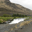
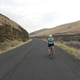
Sherar's Falls Scenic Bikeway
33.4mi
1,727ft
7.2%
00:00
1,735ft
-12.5%
Traverse the strikingly scenic high desert canyon of north central Oregon on this 33-mile loop en route to the Bikeway’s namesake, Sherar's Falls, on the Deschutes River.
The below links provide detailed cues to ride the route in a clockwise direction.
See "Trip Planning Resources" in the Route Details below for cues to ride the route in a counter-clockwise direction.
Wasco County, ORPublic (11,075 views)Created Jul 1, 2015Updated Nov 7, 20226 reviews4 comments


Open gallery (6 photos)
Explore More
Discover your next great ride, courtesy of the largest public bike route library on the internet.
Explore More Routes Like ThisSurfaces
- Paved33.4 mi100%
Cuesheet
- Right on US-1970.2 mi
- Continue on US-1971.0 mi
- Left on OR-2163.7 mi
- Right on Juniper Flat Rd6.5 mi
- Left on US-19713.2 mi
Climbs
- 6.2 mi1,008 ft4.6%
- 0.8 mi151 ft3.8%
Descents
- 1.9 mi588 ft-5.2%
- 0.6 mi111 ft-2.9%
- 2 mi487 ft-5.4%
6
Comments
Beautiful road ride, very scenic with mountain views and waterfalls, varied landscapes. It can get very warm in the high desert environment, so choose a cooler day. White River State Park is a great place for a lunch spot.
Bill N
Lovely, and not nearly as difficult as the map would indicate. Would avoid Imperial however - not hospitable and actually rude. We walked out and didn't patronize either before or after.
The views with low traffic make this ride amazing. We ran into some significant head winds on the last leg along the river. It made the last 5 miles seems like 10! But all worth it 😉
good quiet roads, great scenery, great camping areas at Cove Palisades State Park
Love the wide open views and road along most of this route!
Awesome ride! We rode clockwise and liked eating that hill for breakfast. Ending along the Deschutes is dreamy.
Great route. You can go counter clockwise or clockwise. I prefer to get the 1000 ft. Climb out of the way early. Great ride overall
Rode this one. Great route. Actually prefer it going counter-clockwise since the climb up 216 is a lot less trafficked than the climb up to Maupin.
Ele
Surfaces
Grade
Drag on graph to zoom/select
drag to zoom indistance in miles30252015105ele
(ft)2k1.5k1k
(ft)2k1.5k1k