Missouri Bicycle & Pedestrian Federation
MoBikeFed's favorite bike rides and route collections around Missouri.

Overview
The Missouri Bicycle and Pedestrian Federation is a statewide, not-for-profit, 501(c)(3) membership organization.
The Federation was formed with one goal in mind: to support and protect the rights and interests of bicyclists and pedestrians in Missouri. We make Missouri a better, safer place for bicycling, walking, and trails by championing safety, a world-class statewide bicycling and walking network, and a strong, unified statewide movement that encourages more Missourians to bike and walk more often.
Read more on our website.
Loading your map
Collections

15 Items
Higginsville - Best Bicycle Loop Routes
Some sample bicycle loop routes - paved and gravel - in the Higginsville, Missouri, area.

24 Items
Higginsville Bicycle Touring Routes
These are bicycle touring routes that connect through or near the Higginsville, Missouri, area, and/or ways to connect from & to Higginsville from major cross-state bicycle trails and routes:
*** U.S. Bicycle Route 51 - https://ridewithgps.com/collections/37214
*** Adventure Cycling Association Lewis & Clark Bicycle Route - https://www.adventurecycling.org/routes-and-maps/adventure-cycling-route-network/lewis-clark/
*** Adventure Cycling Association Eastern Express Connector (TransAmerica Trail) - https://www.adventurecycling.org/routes-and-maps/adventure-cycling-route-network/eastern-express-connector/
*** Birthplace of the Santa Fe Trail Bicycle Route, both paved & gravel options - https://ridewithgps.com/events/97552
*** Lewis & Clark Missouri River Adventure - https://ridewithgps.com/events/105329
*** Paved & gravel connections to the Katy & Rock Island Trails in Boonville, Sedalia, Windsor, and Independence
*** Connect to the Butterfield Stage Experience Bicycle Route at Cole Camp or Syracuse - https://mobikefed.org/ButterfieldStageExperience

2 Items
Jefferson City-Boonville Missouri River Adventure - Lewis & Clark-Katy Trail
Experience the full Missouri River adventure in mid-Missouri, riding both sides of the Missouri River valley and fully exploring the Lewis & Clark route between Jefferson City and Boonville.
You've ridden the Katy Trail - now experience it from the other side as you explore little known, seldom visited river vistas, massive bluffs and towering rocks, every Lewis & Clark Campsite, and the real Americana of small-town Missouri.
See Rocheport, Diana Bend, Franklin Island, Huntsdale, Eagle Bluffs, Easley, Hartsburg, the towering Moniteau Bluffs - all from the OTHER side.
As a loop route you can park and ride from Boonville, Rocheport, Jefferson City, or any other convenient location along the route. Or travel to & from in Jefferson City via Amtrak (with your bike!) and make it a 100% car-free vacation.
Most riders will plan 2-5 days for the south side of the river, and another 2-3 days to return via the Katy Trail. But a two-day (or even one-day) trip is certainly possible.

5 Items
Boonslick Road Bicycle Routes
Boonslick Road was Missouri's first main road to the West - was one of very the earliest roads crossing Missouri in the early U.S. period. Following and linking many Native American Trails, Nathan Boone led William Clark along the route in 1808. Soon thereafter, Nathan and Daniel Morgan Boone built the trail into a wagon road between St Charles and their salt spring operation in mid-Missouri.
The route was soon surveyed as the "Missouri Road" became the primary highway for American settlers to travel to mid-Missouri - as well as the wagon road leading to the Santa Fe Trail, the Oregon Trail, and California Trail.
Along this route passed tens of thousands of wagons, travelers, traders, and emigrants from the early 1800s through the Civil War era, on their way to central Missouri, western Missouri, Oregon, California, and other points west.
Along the route are many stations, historic buildings, and ruins dating to the early and mid 1800s.
The Boonslick Road Association has more details about the fascinating history of the road: https://www.booneslickroad.org/

8 Items
Boonville-Rocheport Katy Trail Side Trips and Routes
Several side trips, loops and bicycle route connectors visiting historic and scenic areas of central Missouri are available starting from the Katy Trail in the Boonville-Rocheport area.
Spend an afternoon, a day, or a few days visiting central Missouri's scenery, culture, and history--places few Katy Trail visitors get a chance to see.
Note that these routes are part of MoBikeFed's work to document historic, cultural, and scenic paved, gravel, and trail bicycle routes throughout Missouri. Check each route for details - some are fully vetted, ground-checked routes, others are route plans and ideas that have not yet been fully vetted.
We need your help--if you ride a route and have feedback, contact us at MoBikeFed.org
Note that these routes intersect with several larger systems, including:
- Butterfield Stage Experience bicycle route
- Birthplace of the Santa Fe Trail bicycle route
- Lewis & Clark Missouri River Adventure bicycle route
- Bike MOPAC
- Rock Island/Central Missouri Connectors
Find these and many other bicycle touring routes around Missouri on MoBikeFed's Bicycle & Touring Routes page:
mobikefed.org/missouri-bicycle-and-touring-routes
https://mobikefed.org/missouri-gravel-grinding-bikepacking-bicycle-routes-and-maps

3 Items
Current MO USBR 66 vs Proposed New USBR 66 (9/2024)
The Missouri USBR 51 Organizing Committee is proposing a few updates to USBR 66 in the Springfield area, to improve the route for cyclists and to make the new USBR 51 route and USBR 66 coincide between Springfield and Webb City MO.
To see the new route, zoom into the area immediately around Springfield. BLUE=old route; GREEN=new route.
You can see how USBR 66 will work together with USBR 51 and USBR 251 here:
- https://ridewithgps.com/collections/2948148

4 Items
KGTG Loop - Katy Trail, Tunnel Hill Trail, & Goshen Trail through MO & IL
A 555 mile bicycle touring loop through southeastern Missouri and southern Illinois connecting the Katy Trail, Great Rivers South Bicycle Route, Tunnel Hill Trail, Goshen and Confluence Trails.
Highlights:
* The confluence of America's largest river - the Mississippi - and its longest river, the Missouri.
* Lewis & Clark history and historic sites
* St Charles - Missouri's first capitol
* Washington - historic riverfront town and Missouri's German Heritage Corridor
* Mark Twain National Forest
* Cape Girardeau - Missouri's French heritage along the Mississippi River
* Confluence of the Mississippi and Ohio Rivers. The Ohio is the Mississippi's largest tributary and in fact contributes more water than the Mississippi main stem.
* Railroad history along the Tunnel Hill Trail, following the railroad route built in the early 1870s
* Shawnee National Forest
* Cahokia Mounds World Heritage Site (13-mile optional side trip)
* Edwardsville, 3rd oldest city in Illinois located on Route 66
* Alton, historic Mississippi River town and site of Abraham Lincoln's one and only duel
Trails and routes:
* Katy Trail (eastern portion) - Alton IL to Washington MO
* Great Rivers South Bicycle Route (Adventure Cycling Association) - Washington MO to Cape Girardeau MO and Karnak IL
* The Tunnel Hill Trail - Karnak IL to Eldorado IL
* Newly planned connecting route - Eldorado IL to O'Fallon IL
* The MCT Goshen Trail O'Fallon IL to Edwardsville IL
* The MCT Confluence Trail to Alton IL
What to expect:
The Katy Trail and Tunnel Hill Trails are both state parks - lengthy, soft-surface trails with no motorized traffic allowed.
The Goshen and Confluence Trails are Madison County Transit Trails. These trails and generally paved, with no motorized traffic allowed.
The Great Rivers South section, from Washington MO to Karnak IL is an established Adventure Cycling Association bicycle route. The route is all on paved roads, generally in rural areas with lower traffic counts. However, some sections close to cities and towns will have more traffic. These are generally rural roads with 55-60mph speed limits.
This route begins by crossing the Missouri River at Washington on the new Route 47 bridge. This bridge has a protected 10-foot bike/ped path connecting the Katy Trail to the city of Washington. The connection from the trail to the bridge is still a work in progress, and currently includes a section on Augusta Bottom Road and a short section on the shoulders of Route 47.
The Great Rivers South section of the route crosses the Mississippi River at Cape Girardeau on the Bill Emerson Memorial Bridge/MO-74, which has generous 10-foot shoulders - one of our best Mississippi River crossings.
The section from Eldorado, IL, to O'Fallon, IL, follows scenic, lower traffic rural paved roads. Note that this is the one section of this route that is not well established as a bicycle route - consider this is the first draft of the route through this area, and not yet battle tested.
Connecting the Goshen and Confluence Trails is a short section of low-traffic road.
Connecting the Confluence Trail back to the Katy Trail involves crossing the Mississippi River on the Clark Bridge, which has buffered bicycle lanes - again, one of our best Mississippi River crossing points.
After the Mississippi River crossing, there are a few miles of low-traffic, paved rural roads to connect to the eastern end of the Katy Trail at Machens.
Camping and Lodging
As a rule, the route passes through small cities and towns regularly. You should have no trouble finding convenience stores, grocery stores, and sometimes restaurants and cafes along the route. Many towns will have lodging and/or camping - though pre-plan carefully, as many rural communities have few services available.
These sites have information about the various trails and resources and services along them:
https://bikekatytrail.com/
https://www.facebook.com/groups/615471375669169/
https://www.hikingwithshawn.com/tunnel-hill-state-trail/
https://www.facebook.com/groups/tunnelhillstatetrail/
https://www.mcttrails.org

2 Items
Katy Trail Rocheport I-70 Bridge Construction - Detour Options
MoDOT is building a new I-70 bridge over the Missouri River at Rocheport. This means that the Katy Trail at that point will be closed sporadically between 2022 and 2024. (Note that the trail will remain OPEN through MOST of the construction - closures will just be a few days here and there.)
When the Katy Trail is closed, what are your detour options?
Find out about current trail closures from Missouri State Parks here: https://mostateparks.com/page/84206/katy-trail-state-park-advisory-map
What are your route options to bypass these closures?
Note that, when the Trail is closed, Missouri State Parks has declared the closures to be "hard" closures with no alternative routes available. However - that's not quite true:
This collection includes two really awesome and scenic detour routes for you to consider.
According to Strava Cycling Heatmap, Option #2 (the shorter option) is used more frequently by cyclists. But Option #1, which uses a piece of the Old Boonslick Trail, is ridden as well.
A longer detour option, including the MKT Trail to Columbia and exploring the Old Boonslick Road Rocheport-New Franklin is available here: https://ridewithgps.com/routes/39002432
There are some shuttle services that will bridge the gap for you. Check BikeKatyTrail.com for a list of shuttles: https://bikekatytrail.com/planner.aspx?scid=12&ecid=11&rt=0&rtid=1&svcs=|17|

8 Items
Katy Trail to Flint Hills Nature Trail
Want to put the Katy Trail, the Rock Island Trail, and the Flint Hills Nature Trail together to make an epic, two-state bicycling adventure?
Here is your guide to connecting these three trails in Missouri and Kansas.
NOTE: We have now created DIRECT routes - check them out: https://ridewithgps.com/collections/36150
You can combine the routes on this page with the new routes to make a grand Katy-Flint Hills circuit route.
Description of the route: Take the State Parks Katy/Rock Island Trails to Pleasant Hill, then the Greenwood Gap Connector to Lee's Summit, then the Rock Island Trail northwesterly to its current end point, then Rock Island-Indian Creek Trail connector west or east, then at MILE 10 of that route you take the Blue River Trail south a couple of miles, where you jump on the SFE-03.01P Santa Fe Trail through KC area, joining it around mile 26. Take that to the end of the route at Gardner Junction, then jump on the Santa Fe Trail mostly-gravel option (or paved, if you prefer), taking that west to near Council Grove, KS, where it meets the Flint Hills Trail.
MoBikeFed article about bridging the gap between the Katy & Flint Hills trails: https://mobikefed.org/2020/10/how-connect-mos-katyrock-island-trail-kss-flint-hills-nature-trail-using-trails-low-stress
Katy Trail/Rock Island Trail guide: https://bikekatytrail.com/
Flint Hills Nature Trail: https://kanzatrails.org/flint-hills-nature-trail/
For more bicycle touring routes across Missouri, see:
https://mobikefed.org/missouri-bicycle-and-touring-routes
https://mobikefed.org/missouri-gravel-grinding-bikepacking-bicycle-routes-and-maps

10 Items
Katy/Rock Island Trail to Flint Hills Nature Trail
A collection of routes (some mostly paved, others mostly gravel - so your choice) connecting the Katy/Rock Island Trails in Missouri to the Prairie Spirit and Flint Hills Nature Trail in Kansas.
NOTE: All routes are draft and not ground-truthed. They look pretty good, though!
For more bicycle touring routes across Missouri, see:
https://mobikefed.org/missouri-bicycle-and-touring-routes
https://mobikefed.org/missouri-gravel-grinding-bikepacking-bicycle-routes-and-maps

10 Items
Missouri Rock Island Trail Gravel Route
Missouri's Rock Island Trail from Kansas City to the St Louis metro area is currently partially complete and partially under development
As the trail is developed, you can use these mostly-gravel, low-traffic routes to make all the connections and visit all of the communities along the Rock Island corridor.
Once the trail is complete in each area, these routes remain amazing, scenic, low-traffic routes that you can use to make loops and side-trips from the Rock island Trail to the neighbor countryside.
For more bicycle touring routes across Missouri, see:
https://mobikefed.org/missouri-bicycle-and-touring-routes
https://mobikefed.org/missouri-gravel-grinding-bikepacking-bicycle-routes-and-maps

2 Items
Old Boonslick, Santa Fe, & Katy Trails Loop Tour
Boonslick Road was Missouri's first main road to the West - was one of very the earliest roads crossing Missouri in the early U.S. period. The west end of the Boonslick Road dovetails with the start of the Santa Fe Trail from Franklin to Cooper's Fort
By combining the historic Boonslick Road in this area with the nearby Katy and MKT Trails, loop routes and tours through Columbia to Rocheport, New Franklin, Boonslick State Historic Site, and Boonville exploring the west end of the Boonslick Road, the east end of the Santa Fe Trail, the Katy Trail and the MKT Trails are possible.
A full loop tour Columbia-Boone's Lick-Boonville-Columbia (or making the same circuit starting from any point along the way) is about 95 miles.
The Boonslick Road & Santa FE Trail segments are relatively rugged, hilly, remote, and scenic with many remaining historic buildings and locations. The Katy and MKT Trails are, by contrast, relatively flat, straight, smooth, and well maintained for bicycling. On your bicycle tour, you can spend some time and energy exploring the more remote and hilly Boonslick Road/Santa Fe Trail route - and then return quickly and easily by the much flatter and faster rail-trails.
Following and linking many Native American Trails, Nathan Boone led William Clark along the Boonslick Trace route in 1808. Clark established Fort Osage at the western end of this route. Soon thereafter, Nathan and Daniel Morgan Boone built the trail into a wagon road between St Charles and their salt spring operation in mid-Missouri.
The route was soon surveyed as the "Missouri Road" became the primary highway for American settlers traveling to mid-Missouri - as well as the wagon road leading to the Santa Fe Trail, the Oregon Trail, and California Trail.
Along this route passed tens of thousands of wagons, travelers, traders, and emigrants from the early 1800s through the Civil War era, on their way to central Missouri, western Missouri, Oregon, California, and other points west.
Along the route are many stations, historic buildings, and ruins dating to the early and mid 1800s - as well as a number of well preserved segments of the original route - some almost completely untouched, others part of the county road system but still retaining their rural and remote character.
The Boonslick Road Association has more details about the fascinating history of the road: booneslickroad.org
Note that the route is accessible via the Amtrak stations in Jefferson City or Sedalia (add 30 miles each way from the Jefferson City Amtrak Station to the MKT Trail; 35 miles Sedalia Amtrak-Boonville).

8 Items
Raytown Area Bicycle Connecting Routes
Great bicycle connecting rides and routes centered on Raytown, Missouri. Many of the rides and routes take off from the Rock Island Trail, which runs through the center of the city.
These routes take you from Raytown to somewhere, or from somewhere to Raytown.
You can also check out the Raytown area Loop Routes: https://ridewithgps.com/collections/33310
Also in the area:
Birthplace of the Santa Fe Trail - routes following the Santa Fe Trail from Boonville and Arrow Rock through Independence and Raytown to the Parting of the Trails in Gardner KS and beyond: https://ridewithgps.com/events/97552-birthplace-of-the-santa-fe-trail-bicycle
The Rock Island Trail: Get there from almost anywhere in the Kansas City area: https://ridewithgps.com/events/89549-rock-island-trail-get-there-from-almost-
Rock Island Trail Gravel Routes - travel the entire Rock Island route Raytown to downtown St Louis, via a system of parallel (mostly) gravel roads: https://ridewithgps.com/collections/15786
Bridging the Greenwood Gap - bicycle seamlessly from Raytown to the Katy Trail via the Rock Island Trail and some connectors: https://ridewithgps.com/collections/28919
For more bicycle touring routes across Missouri, see:
https://mobikefed.org/missouri-bicycle-and-touring-routes
https://mobikefed.org/missouri-gravel-grinding-bikepacking-bicycle-routes-and-maps

9 Items
Raytown Area Bicycle Loop Rides & Tours
Great bicycle loop rides and routes centered on Raytown, Missouri. Many of the rides and routes take off from the Rock Island Trail, which runs through the center of the city.
You can also check out Raytown area connecting routes: https://ridewithgps.com/collections/42027
Other area routes:
Birthplace of the Santa Fe Trail - routes following the Santa Fe Trail from Boonville and Arrow Rock through Independence and Raytown to the Parting of the Trails in Gardner KS and beyond: https://ridewithgps.com/events/97552-birthplace-of-the-santa-fe-trail-bicycle
The Rock Island Trail: Get there from almost anywhere in the Kansas City area: https://ridewithgps.com/events/89549-rock-island-trail-get-there-from-almost-
Rock Island Trail Gravel Routes - travel the entire Rock Island route Raytown to downtown St Louis, via a system of parallel (mostly) gravel roads: https://ridewithgps.com/collections/15786
Bridging the Greenwood Gap - bicycle seamlessly from Raytown to the Katy Trail via the Rock Island Trail and some connectors: https://ridewithgps.com/collections/28919
For more bicycle touring routes across Missouri, see:
https://mobikefed.org/missouri-bicycle-and-touring-routes
https://mobikefed.org/missouri-gravel-grinding-bikepacking-bicycle-routes-and-maps

6 Items
Rock Island Corridor: Potential Bypasses & Alternate Routes in Central MO
Some property owners in central Missouri do not want to see a trail built on their section of the Rock Island corridor. Is there a way we could bypass the most problematic sections of the corridor while still maintaining statewide connectivity for the route as a whole?
The blue line represents the Rock Island Railroad Corridor, and the idea of these potential bypasses is to allow some or all segments of the coridor between Eldon and Belle to remain undeveloped.
The maps explore some potential solutions on this issue - potential ways to maintain connectivity of the trail corridor while preserving certain segment of the corridor undeveloped.
These ideas are presented for consideration only, as the starting point for a discussion. Each the potential route could be further refined if those with local knowledge wish to pursue the idea.
Some solutions may be smaller in scale as well: Perhaps a land or right-of-way swap moves the trail in some areas to the borders of land parcels, allowing their present uses to continue without intrusion - while still allowing the statewide trail to maintain connectivity. Disruption to local residents and landowners would be minimized.

9 Items
Saint Louis Metro Area - Katy Trail Connectors
How do you connect from the Kirkwood Amtrak Station, the Amtrak Station Union Station in downtown St Louis, the St Louis Airport, or major trails in the St Louis are to the Katy Trail?
MoBikeFed's collection of bicycle routes and connectors will show you how.
If you would like to contribute a bicycle route to make an important connection from somewhere in the St Louis metro area to the the Katy Trail, please contact us: https://mobikefed.org/about-us
For more bicycle touring routes across Missouri, see:
https://mobikefed.org/missouri-bicycle-and-touring-routes
https://mobikefed.org/missouri-gravel-grinding-bikepacking-bicycle-routes-and-maps

14 Items
Sedalia-Boonville-Columbia-Jefferson City Katy Trail Side Trip & Routes Options
Several side trips, loops and bicycle route connectors visiting historic and scenic areas of central Missouri are available starting from the Katy Trail in the Sedalia-Boonville-Jefferson City area.
Spend an afternoon, a day, or a few days visiting central Missouri's scenery, culture, and history--places few Katy Trail visitors get a chance to see.
You can make Amtrak Connections with your bicycle at Sedalia and Jefferson City.
Note that these routes are part of MoBikeFed's work to document historic, cultural, and scenic paved, gravel, and trail bicycle routes throughout Missouri. Check each route for details - some are fully vetted, ground-checked routes, others are route plans and ideas that have not yet been fully vetted.
We need your help--if you ride a route and have feedback, contact us at http://MoBikeFed.org
Note that these routes intersect with several larger systems, including:
- Butterfield Stage Experience bicycle route
- Birthplace of the Santa Fe Trail bicycle route
- Lewis & Clark Missouri River Adventure bicycle route
- Bike MOPAC
- Rock Island/Central Missouri Connectors
Find these and many other bicycle touring routes around Missouri on MoBikeFed's Bicycle & Touring Routes page:
https://mobikefed.org/missouri-bicycle-and-touring-routes
https://mobikefed.org/missouri-gravel-grinding-bikepacking-bicycle-routes-and-maps

3 Items
USBR 51 Missouri - Spur and Alt Route Options
These are USBR 51 Spur and Alternate Route options that we have considered or could consider in the future for inclusion as part of the Missouri USBR 51 system.

7 Items
USBR 51: Warrensburg-Lexington Route Options (August 2021)
This shows possible USBR 51 route options Warrensburg-Lexington, including possible Higginsville options, for discussion and consideration.
Also included are a scouting ride & drive I took in the area, with some notes and photos.

6 Items
Urich Bicycle Festival 2022 Paved & Gravel Routes
3 paved routes & 3 gravel routes area of Urich, Missouri, for the Urich Bicycle Festival.
YOu can ride loop #1, Loop #2, AND/OR Loop #3 to get 33, 66, or 100 mile routes paved, gravel or even mix the two.
Popular Routes

KCRI-09. KC Airport (MCI) or Downtown Amtrak Station to Rock Island/Katy Trail LS BIDIRECTIONAL (51 miles)
Kansas City, MO
A low-traffic, low-stress route from the Kansas City International Airport and KC Amtrak Station to the 300+ mile Rock Island Trail/Katy Trail system. 52 miles, bidirectional (ride it either direction).
The easiest/best/lowest traffic/most scenic way to connect from the airport/Amtrak to the Rock Island Trail--but also a tour through the heart of the culture, history, art, scenery, food, BBQ, breweries, and fun that make KC a great place to visit and live!
This is a RideWithGPS Ambassador Route - find out more about route details and features on its Ambassador page: https://ridewithgps.com/ambassador_routes/1923-kcri-09-kc-airport-amtrak-to-rock-island
100.6 mi
distance
4,726 ft
elevation

Follow the route of the history Santa Fe, Oregon, and California Trails through Raytown. Along the way, visit a number of Santa Fe/California/Oregon Trail historical sites and other places from the history of Raytown, Jackson County, and the Rock Island Railroad. (20-mile loop, Rock Island Trail + paved low-traffic roads).
On this route you will visit:
* Several miles of the original SANTA FE TRAIL route through this area
* 1830s-era RICE TREMONTI HOME AND FARM
* AUNT SOPHIE'S CABIN - one of the oldest buildings still standing in Jackson County, and home of Sophie White, who began her life as an enslaved person and ended it as a Santa Fe Trail entrepreneur
- CAVE SPRING - first night's camp for many thousands of Santa Fe/California/Oregon Trail travelers, a favorite of PRESIDENT HARRY TRUMAN, whose family owned the site, and still an extensive natural area open for exploration.
* WIEDUWILT SWALES - some of the best-preserved trail remnants in Missouri.
* Meet the trail builders who lived along the trail in this area - from a CIVIL WAR CAPTAIN to a SANTA FE TRAIL FREIGHTER to HARRY TRUMAN'S GERMAN GRANDPARENTS - who were among the early European settlers to this area
An expanded version of this route, with 20-80 mile options, is available here:
https://ridewithgps.com/routes/37400771
This route is based on the Missouri Bicycle & Pedestrian Federation's Santa Fe Trail route through the Kansas City metro area, Wayne City Landing to the Parting of the Trails at Gardner Junction, Kansas. See the full route here:
https://ridewithgps.com/routes/30489594
This route is part of the full Birthplace of the Santa Fe Trail bicycle route network:
https://ridewithgps.com/events/97552-birthplace-of-the-santa-fe-trail-bicycle
* An asterisk at the end of the title denotes a route we consider complete and finalized: Ground truthed/ground-checked, all turns and cues checked.
20.1 mi
distance
1,017 ft
elevation

L&C-01.01P Lewis & Clark Missouri River Adventure: St. Louis Arch-Washington (113 miles, paved/trails, bidirectional)
Washington, MO
Follow the Lewis & Clark Route, starting from Lewis & Clark's starting point at the St Louis Gateway Arch National Park in the heart of historic St Louis to Washington, Missouri.
Mostly paved & trail route; a few gravel roads near Labadie. About 75% paved/20% trail, 5% gravel roads.
****
This route has not been fully scoped or ground-tested. Some indicated roads or connections may not actually exist!
If you would like to ride or drive portions of this to verify it, please contact director@mobikefed.org
****
From the Arch, the route takes the Riverfront Trail along the Mississippi Riverfront past the Eads Bridge, the Chain of Rocks Bridge, and finally to confluence of the Missouri and Mississippi Rivers--where Lewis & Clark's journey really began.
From there, we take the south bank of the Missouri River--the lesser-known bank--past Pelican Island, Saint Stanislaus Natural Area, Creve Coeur Lake--Missouri's largest natural lake, made of a chunk of former MIssouri River Channel--Boone's Crossing, Howell Island, the Missouri River Bottoms near Labadie, the Washington Riverfront Trail, and historic Washington, Missouri.
This route is for river lovers--it goes out of its way to stay close to the river, visit river bottoms, visit Conservation Areas and Wildlife Refuges adjacent to the river, visit river towns, and all the rest. You will have many opportunities for side trips and hikes in conservation areas, natural areas, and wildlife areas--and to see views of the river you can see no other way.
This route is part of the Lewis & Clark Missouri River Adventure bicycle route system (L&C). See MoBikeFed.org/Lewis-Clark
113.1 mi
distance
4,789 ft
elevation
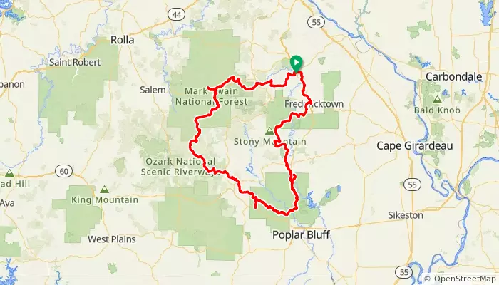
OTMB-GOTE300 - Farmington-Ozark Trail-Fredericktown "Gravel-Ozark Trail Epic 300" (singletrack, gravel)
Farmington, MO
Gravel & Ozark Trail Epic 300 (GOTE 300) bikepacking route by Brian McEntire (310 miles, singletrack/gravel, rugged, difficult, and remote).
The Epic 300 is a truly epic singetrack/gravel bikepacking adventure loop route through some of the most remote, rugged, beautiful, and adventurous sections of the Missouri Ozarks. It takes you to:
- Several scenic, rugged, and remote sections of Mark Twain National Forest
- Council Bluffs Lake
- Ozark National Scenic Riverways
- Farmington
- Bixby
- Bunker
- Owl's Bend
- Ellsinore
- Greenville
- Fredericktown
- and MUCH more
This route has been completely ridden or driven to check it out on the ground. However, note that conditions on the trail and local gravel and forest roads can change quickly.
The route uses:
- The Trace Creek, Middle Fork, Karkaghne, Blair Creek Mountain, Victory, and Wappapello Sections of the Ozark Trail
- The Council Bluffs Lake Trail
- Gravel forest and county roads to connect the trail sections
- a few low-traffic paved roads as needed to complete the loop
This is a rugged, remote, and generally difficult backcountry route with over 20,000 feet of climbing over 310 miles. It includes about 130 miles of singletrack trail (mostly Ozark Trail) with most of the remaining 180 miles gravel roads, some of them quite remote, rugged, steep, and challenging.
The Gravel & Ozark Trail Epic 300 route connecting the Ozark Trail sections has been completely checked out by local cyclists riding and/or driving. Still, you may encounter closed roads or trails, flooded trail, road, or water crossings, road construction, or other route interruptions.
SUPPLY OPPORTUNITIES
Opportunities for resupply are few and far between on the route. Locations with shopping and convenience stores are marked on the route--generally 20-50 miles between re-supply opportunities. However, the Bunker-Ellsinore section is 85 miles between re-supply points.
Generally ample water is available along the route. However, you will need filters and/or water purification systems to make any needed drinking water.
Carry what you need to be self-sufficient and plan on long distances between resupply opportunities. Many areas have no data or cell phone reception and it is recommended to carry an emergency communications device suitable for use in very remote areas.
OZARK TRAIL MOUNTAIN BIKE/BIKEPACKING ROUTE NETWORK
This route is part of the Ozark Trail Mountain Bike/Bikepacking Route Network: https://ridewithgps.com/events/95771-ozark-trail-mountain-bike-bikepacking-ro
OZARK TRAIL ASSOCIATION - MAIN INFORMATION SOURCE FOR THE TRAIL
The Ozark Trail Association is the primary resource for information about the Ozark Trail:
https://www.ozarktrail.com/
OTA has a page listing extensive trail services, including lodging, camping, shuttles, and more:
https://www.ozarktrail.com/trailservices-2/
310.9 mi
distance
20,490 ft
elevation

MOPAC-01L. Missouri Pacific RR Historic Route - Frisco Loop through STL County (bidirectional)
St. Louis, MO
This optional loop parallels the Frisco line and visits numerous Frisco line stations in St Louis County--some still existing, and some long gone. v
This route is generally more complicated and also follows some higher-traffic streets, in order to access the Frisco line locations. The Frisco generally parallels Big Bend Road today.
40.6 mi
distance
2,206 ft
elevation

KCRI-11L Round Grove Creek Loop - Raytown - Rock Island Trail (23 miles, mostly paved, loop route) ***
Kansas City, MO
This is a 23-mile loop route you can ride from the northern end of the Jackson County Rock Island Trail in Raytown. The route combines the Jackson County Rock Island Trail with the Blue River Trail. (Mostly paved, loop, 25 miles.)
The route adds and approx. 10 mile loop to the northern end of the Jackson County Rock Island Trail. The route is mostly paved but some sections of both trails are soft surface.
The route is a guided tour of area history and culture, with cues telling you about highlights of area and neighborhood history as you ride, and points of interest giving more detail.
The route visits a number of historic sites, including farm sites of early Raytown settlers, Knobtown, Hinkle's Ford and Simmon's Ford (important in Civil War Battle of Westport and history of the area), places and people touched by Quantrill's Raiders and the 1850s-60s "Bloody Kansas" and "War Along the Border", a portion of historic Raytown-Westport Road (part of the Santa Fe/Oregon/California trail system), Truman Sports Complex (home of the Chiefs and the Royals), the Blue River, the Kansas City Municipal Farm and Poor Farm, currently undergoing renewal and re-use, the historic Leeds neighborhood, 1929 Chevrolet/GM Leeds Assembly Plant, and more.
The route makes connections among major bicycle (and historic trails) routes through the area:
- Jackson County Rock Island Trail - which in turn connects to the Missouri State Parks Rock Island Trail/Katy Trail system
- Blue River Trail - planned to stretch from the Missouri River southwest to the Kansas state line.
- Brush Creek Trail - connecting to The Plaza and other points in midtown and downtown Kansas City.
- Old Santa Fe Trail Westport-Independence connector - which is an excellent bicycle route to Westport and Downtown areas of Kansas City
The route shown starts and ends at the Brickyard Road trail access point between Raytown and Lee's Summit. However, the route can be started/ended anywhere along the Jackson County Rock Island Trail from the Truman Sports Complex in the northwest to the southeast end of the trail in Lee's Summit.
*** indicates a "Three Star Ride": The route had been ground-truthed, all cues and turns checked, and the cues include additional "guided tour" detail.
23.4 mi
distance
1,158 ft
elevation

Raytown: Crane Brewing-Rock Island Trail-Blue River Trail loop (14 miles, paved, loop route) ***
Raytown, MO
This is a 14-mile loop route from Crane Brewing in Raytown, incorporating the Rock Island the Blue River Trails. (Paved, loop, 14 miles.)
The route generally follows the trails and, where needed make connections, lower-traffic local roads.
The route as shown starts and ends at Crane Brewing in Raytown, but it can be ridden from any point on the Jackson County Rock Island Trail in the Raytown-Kansas City-Lee's Summit area by simply riding the trail to Crane Brewery and then beginning the loop.
In addition to being an excellent route - one of the most popular with area cyclists even before the Rock Island Trail and Blue River Trail improved it - the route is a guided tour of area history and culture, with cues telling you about highlights of area and neighborhood history as you ride, and points of interest giving more detail.
The route visits a number of historic sites, including farm sites of early Raytown settlers, Knobtown, Hinkle's Ford, Byram's Ford, and the location of the Battle of Byram's Ford (important in Civil War Battle of Westport and history of the area), places and people touched by Quantrill's Raiders and the 1850s-60s "Bloody Kansas" and "War Along the Border", a portion of historic Raytown-Westport Road (part of the Santa Fe/Oregon/California trail system), Truman Sports Complex (home of the Chiefs and the Royals), the Blue River, the Kansas City Municipal Farm and Poor Farm, currently undergoing renewal and re-use, Swope Park, and more.
The route makes connections among major bicycle (and historic trails) routes through the area:
- Jackson County Rock Island Trail - which in turn connects to the Missouri State Parks Rock Island Trail/Katy Trail system
- Blue River Trail - planned to stretch from the Missouri River southwest to the Kansas state line.
- Brush Creek Trail - connecting to The Plaza and other points in midtown and downtown Kansas City.
- Old Santa Fe Trail Westport-Independence connector - which is an excellent bicycle route to Westport and Downtown areas of Kansas City
*** Indicates this route has been ground-checked, all cues checked, and it is a "guided tour" route with information about nearby points of interest included in the cues.
14.1 mi
distance
707 ft
elevation

This route follows the historic Raytown-Westport Road as well as the Independence-Westport Santa Fe Trail route, from Raytown to Westport and back.
Along the way, you'll visit many Santa Fe Trail and Battle of Westport Civil War historic sites.
This is similar to SFE-03.05PL - Battle of Westport Civil War Bicycle Tour (https://ridewithgps.com/routes/32539984) and visits many of the same sites, but is a shorter variant.
27.1 mi
distance
1,510 ft
elevation

RIGC-1G. Rock Island/Lee's Summit to Pleasant Hill Connection (more gravel, bidirectional) ***
Lee's Summit, MO
Rock Island Trail Greenwood Connector - Route 1G (more gravel) - bidirectional - Greenwood Connector route with somewhat more gravel/more scenic south of Greenwood (compared with the RIGC-1P route, this route has quite a bit more gravel and the gravel is rougher and steeper. However it is more scenic! Compared with the RIGC-1L route, this has a little more traffic around Greenwood, but also visits two parks with facilities and a convenience store in Greenwood).
The route is BIDIRECTIONAL, meaning that you can jump on and ride the route in either direction.
The Rock Island/Katy Trail system in Missouri stretches over 300 miles across the state. But there is a short 11-mile gap in the trail between Lee's Summit and Pleasant Hill.
This map has directions for a low-traffic road route to bridge that gap in the southeast direction--Lee's Summit to Pleasant Hill.
Note that this route takes you past two parks (restrooms in the Summer - water at Liberty Park Greenwood may be on year around) and a convenience store in Greenwood. The tradeoff is several blocks of slow-speed (25 MPH) but higher-traffic roadway on Allendale Lake Road in Greenwood.
This route is mostly paved - except for a fairly extensive gravel section starting a couple of miles south of Greenwood. The gravel section is longer, steeper, and generally more challenging than the relatively short, smooth, flat gravel section in RIGC-1P. This route takes you past Allendale Lake and is a bit more scenic.
The route has one convenience store (Caseys in Greenwood - generally open 7am-11pm) and one location where you should be able to find water all year around (Liberty Park in Pleasant Hill). Allendale Lake Park on the south side of Greenwood has restrooms that are generally open in good-weather months.
If you want to more completely avoid traffic, you can try the L (longer) route - RIGC-1L. If you want less gravel and more pavement, try RIGC-1P.
More information: http://mobikefed.org/2019/04/369-miles-connected-trail-across-missouri-new-rock-islandkaty-trail-connections-maps-routes-
*** This is a MoBikeFed THREE STAR ROUTE, meaning: (1) The route has been completely ridden and ground-truthed, (2) All turns and cues have been checked, and (3) the route cues include some information about the area as a "guided tour" that you will hear as you ride.
25.6 mi
distance
1,266 ft
elevation

This is a FLAT HALF CENTURY route that features more miles on the Frisco Highline Trail and fewer hills/less climbing than the Main Route.
NOTE: The route option has one REST STOP at the Willard Trailhead, mile 14 and mile 35. It is about 20 miles from the Willard Trailhead Rest Stop to Walnut Grove and back.
The TURNAROUND POINT is the Mays Mart Convenience Store in Walnut Grove, mile 24.5 (restroom, water available, snacks for purchase).
This route includes a ****soft-surface portion of the Frisco Highline Trail between Willard and Walnut Grove****. This section of the route is a good-quality soft surface, similar to the Katy Trail, and is generally rideable by road bikes.
The remainder of the route (ride start to Willard Trailhead) is on paved road or paved trail.
The route visits or crosses several of the statewide and national bicycle touring routes that MoBikeFed helps develop and maintain in Missouri:
Bicycle Route 66 (USBR 66) - Springfield: https://mobikefed.org/missouri-bicycle-maps-and-routes#route66
TransAmerica Trail (USBR 76) - Ash Grove & Walnut Grove: https://mobikefed.org/missouri-bicycle-maps-and-routes#transam
USBR 51: Downtown Springfield through Frisco Highline Trail section: https://mobikefed.org/missouri-bicycle-maps-and-routes#usbr51
Butterfield Stage Experience mostly gravel bicycle route: Frisco Highline Trail through downtown St Louis section: https://mobikefed.org/ButterfieldStageExperience
In addition, the turnaround loop of the century option follows a section of the original Butterfield Stage route through this area.
The route SW of Willard follows the paved section of the Frisco Highline Trail, a trail developed and maintained by Ozark Greenways on the historic Frisco Highline railroad route.
Find out more about the 2022 Queen City Century or register for the ride here: http://QueenCityCentury.org
46.7 mi
distance
1,202 ft
elevation

Butterfield Stage Experience EAST - mostly gravel bicycle route Jefferson City (all services) - California (history, lodging, restaurants, shopping) - Tipton (shopping, restaurants, lodging, Butterfield Monument) (Trails/gravel/paved. 46 miles. Eastward direction.)
46.4 mi
distance
2,285 ft
elevation

BSE-6N. Springfield-Bolivar: Butterfield Stage Experience
Springfield, MO
Butterfield Stage Experience NORTH: Mostly gravel/low-traffic scenic route Bolivar (all services, Butterfield monuments) to Springfield (all services, Butterfield monuments) via the Frisco Highline Trail.
Many amenities and interesting sites along the trail--find them here: https://ozarkgreenways.org/explore/greenway-trails/frisco-highline-trail/
43.8 mi
distance
1,137 ft
elevation

How to use low traffic/low stress roads connect from the Indian Creek Trail through Hickman Mills, South Kansas City, Leawood, Lenexa, Overland Park, Olathe, etc, to the north terminus of the Rock Island Trail Phase 1 in Lee's Summit.
More info at https://mobikefed.org/rock-island-trail-western-connections#kc
This also connects to the Blue River Trail, the Trolley Track Trail, Tomahawk Creek Trail, and other destinations on the south side of the KC metro area to the Rock Island.
33.1 mi
distance
842 ft
elevation

Gravel/paved route between Hermann and St. Louis Union Station, closely following the original, historic Missouri Pacific Railroad route and visiting many historic railroad sites and attractions. (Mixed gravel/low-traffic paved roads/trails. 107 miles each way. Bidirectional.)
This is the Bike MOPAC route between downtown St Louis and Hermann (MOPAC-01), and also serves as one option for the Lewis & Clark Missouri River Adventure Bicycle Route (L&C-02.01G).
On your way from Jefferson City to St. Louis, you will visit historic railroad stations and historic sites at Jefferson City, Hermann, New Haven, Washington, Pacific (re-named after the railroad), Barrett Station, Webster Groves, Tuxedo Park, Kirkwood (named after one of the railroad designers), Cheltenham, Union Station/St Louis and more.
Highlights of this segment:
- Tour of downtown St Louis, historic railroad headquarters and depots, Gateway Arch National Park, historic (and still currently active) railroad yards and stations
- Many historic and still-existing MOPAC and Frisco stations scattered through St Louis County communities
- National Museum of Transportation with numerous MOPAC engines, cabooses, railroad cars and historical exhibits--and a station, historic tracks segments, and the first two railroad tunnels west of the Mississippi built for the MOPAC line.
- Meramec Highlands Frisco Railroad Tunnel hike
- 12-inch gauge live steam engine-powered train still running weekly in Wildwood area
- Route 66 sites St Louis City-Gray Summit
- Historic railroad stations and buildings in Pacific, Labadie
- Amazing historic downtown and MOPAC station area in Washington--well preserved stations, caboose, and copious historical markers
- New Haven historic buildings, Lewis & Clark memorials, John Colter memorials
- Hermann Farm Museum
- Historic downtown Hermann, MOPAC history, and Deustcheim Historic site
Amtrak still follows the historic Missouri Pacific route, so you can conveniently take your bike on Amtrak and pick up a ride or complete the route at Union Station St Louis, Kirkwood, Washington, Hermann, or Jefferson City.
217.5 mi
distance
10,917 ft
elevation
Get Inspired, Not Lost. © 2025 Ride with GPS.Terms of Service.Privacy Policy.