Seattle International Randonneurs

Top cycling routes and ride collections by Seattle International Randonneurs

Overview

About Randonneuring

Randonneuring is self-supported long-distance cycling. It's a great sport for those who love to ride their bikes, explore new roads, and discover what is over the next hill. Our rides are scenic and challenging. Perhaps most enjoyable is the camaraderie among randonneurs. Randonneuring is not a race, but the time limits makes it challenging nonetheless.

Randonneuring celebrates self-sufficiency. On a brevet or a permanent, you are on your own ride. The self-sufficiency of randonneuring means that you are responsible for your own pace, your own nutrition, your own repairs, and, above all, your own safety. Although other riders, or the organizers, may offer assistance, the ultimate responsibility lies with you.

Randonneuring is a big tent where every rider finds their challenge. Some aspire to finish within the time limit, others try to set a personal best, and yet others want to go as fast as possible. Some concentrate on the longest distances (1000 km and beyond), others do the day rides (100, 200 and 300 km). All are randonneurs. At Seattle International Randonneurs, each rider is respected. We are all out to have fun!

Randonneuring rides (called populaires or brevets) vary in length between 100 km (62 miles) and 1200 km (750 miles). Riders are given a route sheet and a control card, which they have signed at predetermined points to show that they have completed the course.

Check our calendar for upcoming populaires and brevets and come join us on a ride!

Loading your map

Collections

9 Items

Seattle-Crater Lake Tour

Here is a chain of 100-200 km permanents that generally follows the Craters 1200 brevet route. Ride one a day, take rest days, or challenge yourself by riding several straight through. An entrance fee or National Park pass is required to enter Crater Lake National Park (Stage 7) (or stage 8/8 alt if riding in reverse). Stages 1, 7, 8, and 8 alt are not rideable in winter when snow closes the high mountain roads. The rim of Crater Lake reaches 7600 ft. It is subject to quickly changing mountain weather. Check the forecast before you go and be prepared for worse conditions than you expect. For current conditions at Crater Lake and recent history of opening and closing dates see: https://www.nps.gov/crla/planyourvisit/hours.htm Several of the stages have long stretches without services. Plan carefully. Amtrak is a popular method of returning to Seattle from Klamath Falls. For that reason Stage 1 begins at the Amtrak terminal at Seattle's King Street station. There are many commercial parking lots in the vicinity. On-street public parking is limited to three days, so street parking will not be an option for most people. A Link Light Rail station is a few blocks away, offering easy access to the Seatac airport-Northgate corridor. The stages generally end in towns offering a selection of restaurants and accommodations from camping to hotels. To avoid backtracking between finish, lodging, and start in larger towns, a stage ends when entering the town and the next begins where the route leaves the town. You are on your own to find your way to your lodging and to the next stage's start. Crater Lake is an exception. The only lodging at the rim is the Crater Lake Lodge, where availability may be the deciding factor for scheduling your entire trip. Alternatives are to continue to Klamath Falls on one of the Stage 8 routes, or stay at Mazama Village 1100 ft below the rim (and then climb back up to start the last stage). Two routes are provided for the last stage from Crater Lake to Klamath Falls (Stages 8 and 8 alt). The longer route, Stage 8, circles the rim and descends past The Pinnacles. At The Pinnacles there is about 1 km of well-graded gravel trail. The shorter route, Stage 8 alt, takes the most direct route. The shorter route may be preferred if you are riding from Roseburg straight through to Klamath Falls for a total of 263 km and 13,800 ft of climbing at altitudes up to 7600 ft. An alternate start can be made from Portland using permanent 02016 Tillamook Stomp from Hillsboro to Tillamook. Currently this permanent is inactive. (No RUSA credit.)

Popular Routes

RUSA Permanent A 70% gravel loop featuring Snoqualmie Valley Trail, Tolt Pipeline Trail, and Snoqualmie Forest (permit required!). From North Bend (elevation 440'), you'll first ride by and then away from Mount Si on paved roads before hopping on to the Snoqualmie Valley Trail. Enjoy a long gradual downhill on this gravel rail trail before getting off at the historic train depot near downtown Duvall (elevation 89'). Restock in Duvall as necessary, then follow the Tolt Pipeline in a mostly straight line towards the reservoir, first on gravel trail, and then on pavement beyond the Kelly Rd gate. The third and final stretch of gravel starts with the mainline of Snoqualmie Forest (permit required!). Enter from Gate 27, and after gradually climbing to ~1400 ft, you'll head southbound and exit via Gate 10 to NF-5700/N Fork Rd SE. Mount Si welcomes you back as it returns to view on a steep partially-paved descent back down to North Bend. ⚠️ CAUTION! ⚠️ ⚠️ You MUST have a valid non-motorized recreation permit from Campbell Global (https://sqrecreation.com) to ride your bicycle in Snoqualmie Forest ($8/day or $50/year) ⚠️ Snoqualmie Forest is closed to recreation during periods of high fire danger. Check status and confirm that it's open before riding! ⚠️ You MUST follow the rules and regulation for non-motorized recreation access while riding in the Snoqualmie Forest. Violation will result in revocation of your permit. ⚠️ Study the map carefully ( https://www.sqrecreation.com/snoqualmie/about/vicinity-map/vicinity-map ); bring a copy with you in case you get lost. GPS device is highly recommended. ⚠️ DO NOT trespass into protected watershed territory; you WILL be arrested! ⚠️ Hunting is permitted in Snoqualmie Forest; wear high visibility apparel and stay on the roads! ⚠️ There is no cell phone reception in Snoqualmie Forest! Don't take unnecessary risks and make sure you're adequately prepared.

62.8 mi
distance
2,726 ft
elevation
Check road conditions here before riding: https://www.fs.usda.gov/alerts/mbs/alerts-notices https://www.fs.usda.gov/detail/mbs/conditions/?cid=STELPRDB5126323 http://www.goldmyer.org/weather.php (weekly access report) A mixed-terrain out-and-back into Middle Fork Valley of Snoqualmie River, going as far as bikes are allowed to go to the Alpine Lakes Wilderness boundary at Dutch Miller Horse Camp. The route starts in downtown North Bend. The gravel starts immediately with a short ride northbound on Snoqualmie Valley Trail just past the Three Forks Natural Area, the confluence of the South, North, and Middle Fork Snoqualmie River. Return to North Bend for a last chance to pick up supplies, then continue southbound to hop on pristine paved roads leading into Middle Fork Valley. The pavement eventually ends and the unpaved forest road only becomes more adventurous the farther you go, as you climb up to ~2800 ft. The road becomes a trail into Alpine Lakes Wilderness at Dutch Miller Horse Camp, so this is where you turn around and return downstream back to North Bend. ⚠️ CAUTION! This is a wild adventurous ride in a remote region prone to landslides, rockfalls, floods, and snow in winter. Be prepared for outrageous terrain that may require some walking. Expect no cell phone service. The only source of readily potable water is at the Middle Fork Campground.

62.2 mi
distance
3,611 ft
elevation
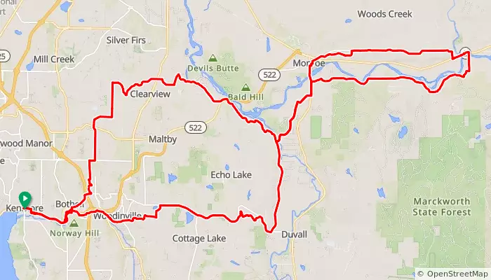
Kenmore to Sultan via Woodinville-Duvall and Ben Howard and back to Kenmore via High Bridge and Interurban Boulevard

65.7 mi
distance
3,295 ft
elevation
RUSA Populaire #2514 This is based on 1004 Lake Washington-Lake Sammamish Loop with the bottom part routed across Mercer Island and through Factoria (Factoria-Issaquah-Lake Forest Park-Seattle-Mercer Island-Factoria). A generous climb from Factoria starts up to Eastgate and down into Issaquah. The middle of the route is largely flat along East Lake Sammamish Trail, Sammamish River Trail, Burke-Gilman Trail, Lake Washington Blvd. Mercer Island presents rollers and turns before you finish back in Factoria. Controls: 1. Factoria AAA - start 2. Issaquah 3. Log Boom Park 4. Mercer Island 5. Factoria AAA - finish RUSA Brevet Route # 2514

62.6 mi
distance
2,364 ft
elevation
Start/Finish 10 min from ID & Beacon Hill Light Rail Control times: Checkpoint Date Time ========== ==== ==== Dandelion Cyclery 0km start: 06/18 09:00 (0mi) close: 06/18 10:00 WOOD SHOP BBQ 101km open: 06/18 11:56 (63mi) close: 06/18 15:40

62.8 mi
distance
2,199 ft
elevation
RUSA brevet #2962 Based on permanent 3653. Control open/close times (elapsed time) using RUSA gravel timing: Start Vintage Baristas, North Bend Distance: 0km / 0mi Open: +0h 0m Close: +1h 0m "Avalanche!" (Untimed, for reference) Distance: 51km / 32mi Open: +1h 30m Close: +4h 26m Finish The Pour House, North Bend Distance: 102km / 63mi Open: +3h 0m Close: +8h 29m This route is a jaunt up to Keechelus Lake and back down on the Snoqualmie Valley and Iron Horse Trails. We go through the 2.5-mile long Snoqualmie tunnel in each direction. The entire route is on easy gravel generally at a uniform 1-2% railroad gradient. GOOD LIGHTS ARE MANDATORY FOR THE TUNNEL! There is no artificial light in the tunnel! Expect to encounter pedestrians with poor lights and no reflective gear. The tunnel is always cold! Water and heated restrooms are available at Hyak. The spigot on the restroom building at Hyak has been removed. Water is available in the restroom sinks. There is no food on the route.

63.6 mi
distance
3,348 ft
elevation

2879 Mercer Island-Auburn

Mercer Island, WA
RUSA Permanent

62.5 mi
distance
1,413 ft
elevation
Brevet #2269

63.6 mi
distance
2,970 ft
elevation
Brevet Route #1446 New Snoqualmie River Run

68.3 mi
distance
2,075 ft
elevation
RUSA #2907

67.9 mi
distance
3,320 ft
elevation
Explore Routes