Mobile App
Plans
Route Planner
Organizations
Explore
Stories
English
Log In
Sign up
Sign up
Rick Studley
Clifton, Virginia, US
Follow
Message
Stats
2025
- -
Feet Traveled
- -
Feet of Elevation Gained
- -
Activities
- -
Active Hour
- -
Calories Burned
- -
Photos Taken
Week
Month
Year
Career
Recent Routes & Activities
60/40
Fauquier County, VA
28.6 mi
2,271 ft
Afternoon Trainer from Delaplane
Fauquier County, VA
37.5 mi
2,145 ft
BRP - Alhambra Out-and-Back
Amherst County, VA
41.2 mi
5,047 ft
Mariette's Folly
Buena Vista, VA
60 mi
5,919 ft
(unnamed)
Warren County, VA
81.5 mi
7,621 ft
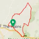
Short & Hilly... Mostly gravel
The Plains, VA
25.8 mi
1,963 ft
From Lexington, up Irish Creek (including gravel)
Lexington, VA
48 mi
3,811 ft
Variation on Mariette's Medio Gravel Grinder
The Plains, VA
37.1 mi
2,216 ft
Mixed surface Ft. Valley...
Shenandoah County, VA
50.9 mi
3,714 ft
Meandering Fort Valley - with a couple ridges for good measure.
Shenandoah County, VA
50.9 mi
3,714 ft
Wandering to Manomet
Plymouth, MA
26.6 mi
1,395 ft
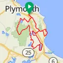
Modified Gravel Loop(s)
Plymouth, MA
54.6 mi
2,850 ft
East to West over Mt. Weather and Naked Mountain
The Plains, VA
75.4 mi
5,313 ft
Not quite 40 on Gravel
The Plains, VA
39 mi
2,566 ft
Front Royal to Pinnacles Overlook
Warren County, VA
70.2 mi
7,588 ft
Crabtree-Irish Creek-BRP
Beech Grove, VA
75.4 mi
6,974 ft
80-percentury
Beech Grove, VA
80.1 mi
7,600 ft
96-percentury
Beech Grove, VA
95.9 mi
9,224 ft
Fort Valley, Moreland Gap, Woodstock Tower (variation)
Warren County, VA
75.7 mi
5,299 ft
Bull Run x2
The Plains, VA
43.6 mi
2,830 ft
Follows
2 followers
2 following
Greg Gibson
Maarten Prins
Recent Photos
This user has not uploaded any photos
Get Inspired, Not Lost. © 2025 Ride with GPS.
Terms of Service
.
Privacy Policy
.
Mobile App
Mobile Route Planner
Web Route Planner
Integrations
Organizations
Experiences
Cycling Clubs
Cycling Events
Regions
About Us
Global Ambassadors
Careers
Contact
Help Center
Facebook
Twitter
Instagram
YouTube