Hundo_and_13_Po

Tour of River Basins Around Harrisburg

Aperçu de l'itinéraire

184 km
2 192 m

A ride from the West Shore of Harrisburg, heading north into Perry County, ascending a Category 3 climb, then a scenic ride up through Clarks Valley, ascending another Category 3 climb, a breathtaking descent at high speed, followed by heading straight up a Category 4 climb. Another descent and a trip though Fort Indiantown Gap military base, before heading west again, travelling along the Susquehanna River on the East Short of Harrisburg, before crossing the river to finish the ride

Détails de l'itinéraire

This ride is a great ride for a Saturday, as you will have plenty of time on Sunday for recovery riding or relaxing. This ride takes you from the surburbs of the West Shore of Harrisburg, into the beautiful rolling hills of Perry County, makes it's way into Dauphin County via a mountain pass and into the Clarks Creek basin and DeHart Dam Watershed before a double mountain pass takes you through Fort Indiantown Gap. A pass down through Fishing Creek Valley brings you to the East Shore of Harrisburg, along the beauty of Front Street, before your final segment back onto the West Shore of Harrisburg. 3 mountain passes, 3 bridge crossings over scenic rivers, and miles of Central PA beauty.

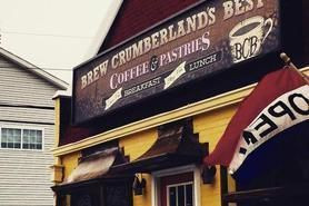
Our ride begins almost at the highest point of the town of New Cumberland, PA on Davis Drive. This town has almost a nonexistent crime rate, so your vehicle will be safe parked on Davis Drive. A left onto 7th street from Davis Drive and there is a short sharp climb (less than 100 yards) and a right turn onto Allen Street puts you on a nice downhill leading you to Simpson Ferry Road. After a left on Simpson Ferry Road, a few strokes of the pedals and you will turn right onto Locust Street. A right onto Sherwood Road, a left onto Brandt Avenue, and a right onto Carol Street gives the rider a calm warm up on low traffic roads. After making a left onto Bridge Street if you need a little spark, be sure to visit Brew Cumberlands Best, located at 1903 Bridge Street.

The route passes through the small boroughs of Lemoyne and onto Front Street in Wormleysburg. At this point you can take in a great view of the Susquehanna River and the Harrisburg City Skyline past City Island and baseball park of the hometown Harrisburg Senators.

PA Route 15 merges onto Front Street just north of Wormleysburg as the route passes through the boroughs of West Fairview and Enola. Here the shoulder can be tight in a few spots so hyperawareness is good through this section.

After passing under Interstate 81, the route passes into Perry County. The rider is shortly exposed to the one and only traffic light in all of Perry County at the intersection of Route 15 and Route 850. A left is made onto Route 850 and immediately the landscape changes to rolling terrain. There is an immediate climb out of town that begins the rolling terrain. However, the road surfaces are smooth, the shoulders are wide and the traffic is friendly to cyclists.

At kilometer 33.1, a right turn is made onto Pine Hill Road. Our first real climb is on this road, consisting of a 1km climb that gains 78 meters with an average gradient of 8% and a maximum gradient of 14.2 percent. Your efforts are rewarded with a 3 km downhill section that loses almost 100 meters in elevation. A right onto Dellville Road comes at the bottom of this long downhill section.

The next 14 km are all large rollers where any off-season interval training will pay off. At kilometer 41.9, a left turn is made onto Linton Hill Road. Powering up hills, followed by periods of downhill recovery, along with wonderful scenery, is a perfect prelude to making a right onto PA State Route 849 (Newport Road) with a long elevation drop into Duncannon.

Cruising into the town of Duncannon, a right onto Market Street, a right onto Cumberland street and a stop at the Quick Mart, located at 69 Cumberland Street, is necessary for refueling and hydration, as the first categorized climb awaits.

Reversing and backtracking through Duncannon back to Newport Road, we are met with 2 bridge crossings. First up is the bridge over the Juniata River. This bridge is narrow, is in average road condition, with literally no shoulder. Fortunately, it is only 0.25km long. After the bridge, it is a right turn onto State Route 322 and a crossing of the Susquehanna River.

Fortunately, the Route 322 bridge does have an elevated sidewalk, which makes for a much safer crossing and a great view of the Susquehanna River. Stop and take a picture for the memory book.

After traversing the bridge, we make a left onto PA State Route 147. At kilometer 61.7, a right is made onto Mountain Road. This is the prelude to the first categorized climb- Peters Mountain.

A right from Mountain Road onto State Route 225 (Peters Mountain Road) and you are put right to work. The climb is arduous, reaching a maximum gradient of 13.2% and a warning that the shoulder can be narrow at times, and sometimes littered with rocks that have fractured off the hill from frost. These rocks can range in size from tennis balls to soccer balls. The vehicles are travelling at a high rate of speed in order to keep momentum as the mountain is climbed. The road switches back at the peak, as you pass under a foot bridge that is the Appalachian Trail.

Your strenuous effort is rewarded with a descent that can last only 2 minutes for the strong descender.

After that effort and calories burned, it's time to reward yourself at 3B Ice Cream, located just before the next turn on the route. This facility not only has the best ice cream in the area, it is a wonderful place to attempt to top off the tank in preparation for the next categorized climbs which are approximately an hour away, as hot food in the form of burgers, subs, and sandwiches are also on the menu.

A left onto PA State Route 325 and the rider is again rewarded with generous shoulders, a recently refinished road surface, gently rolling terrain, and nothing but nature surrounding the rider. The rider will pass the DeHart Reservoir, which is the water supply for the City of Harrisburg. Wildlife sightings are commonplace here.

Just north of the intersection of PA State Route 325 and Gold Mine Road, there is a small family owned eatery called Wild Bills at 260 Clarks Valley Road Tower City, PA 17980. There is a selection of home-cooked style food as well as the usual convenience store food. Again, it is recommended to get the large portion of fuel on board at 3B Ice Cream and possibly focus on hydration replenishment at this facility, plus filling the jersey pockets with food for nourishment between here and Harrisburg.

Heading back to the intersection of Clarks Valley Road and Gold Mine Road, the rider heads south on Gold Mine Road to the Category 3 climb that awaits. What makes this climb so challenging is there is a short steep downhill (-9.3%) prior to the actual climb. Added to that is the first 1km of the climb is a straight hill. As being taught not to look all the way up the hill when climbing, this section makes it difficult to do so. The road then gently curves to the right and again continues on a straight path until a 19.6% gradient in a switchback. 0.2km and you're over the top. The back side of the mountain does not offer the steep downhill for which to gain momentum for the Category 4 climb that immediately follows. The only reason for the Category 4 designation is that the length of the climb is not as long.

After the Category 4 climb, there is a fast and long descent down into the valley, as close to 150 meters in elevation is lost on the descent.

A right onto Route 443 from Gold Mine Road puts you onto a road that has an immensely wide shoulder and wonderful road surface. Route 443 turns right onto Moonshine Road. Over the next 5k, there is 80 meters of elevation gain. At the top of this elevation gain the rider enters into Fort Indiantown Gap Military Base. *** Caution must be taken as the rider starts to descend to not exceed the 25 MPH speed limit which is strictly enforced***

Route 443 again makes a right at a T intersection and begins to head southwest toward the Harrisburg area. This is a great place to hit any nutrition that one has stored in the jersey pockets after the climbing efforts on Gold Mine Road.

Over the next 15 km, there is approximately 60 meters of elevation gain, then the elevation is continually dropping in the following 15km as the rider traverses rolling terrain back toward the Susquehanna River.

A left onto North Front Street from Route 443 is made at kilometer 165.4, and the Susquehanna River then appears on the riders right. A particular point of interest is Fort Hunter at kilometer 165.8, which was built by the British during the threat of the French and Indian War.

After passing Fort Hunter, the world's longest stone arch bridge, Rockville Bridge can be seen spanning a railroad track from east shore of the Susquehanna River to the west shore.

As the rider travels down through North Front Street into Harrisburg, there are a few fast food and convenience store establisments on the East side of Front Street if reserves are running low.

There are options for a riding on a paved multipurpose trail known as the Capitol Area Greenbelt that parallels Front Street. This trail starts at approximately the intersection of Front Street and Vaughn Street, the 170.9km mark.

Starting at Maclay Street and Front Street, kilometer 173.4, there is a second optional trail that runs immediately next to the riverbank. This trail is also paved and there are several entry and exit ramps to and from the riverside trail and the Capital Area Greenbelt Trail.

A right is made onto the Market Street Bridge at kilometer 176.1, which is bridge used by motorists and cyclists to not only travel from East Shore to West Shore, but also to access City Island, which was mentioned earlier in the route description.

After crossing Market Street Bridge, the rider will travel approximately 1km on Market Street, then bear left onto State Street.

The end of the ride is approaching. A left onto 17th Street, a small bridge crossing over a railroad bed, a left onto Hummel Avenue, a right onto South 10th Street, a right onto Lowther Road and a left onto Carlisle Road which becomes Simpson Ferry Road.

A right back onto Allen Road, and the rider climbs the long downhill that was descended at the beginning of the ride. After cresting the hill, the road becomes Davis Drive and we have a gentle rolling downhill back to our parked vehicle.

For post-ride nourishment, a burrito from Neato Burrito located at 316 4th Street, Unit #2 is only a 3 minute drive away.

More resources

Brew Cumberland's Best

Quick Mart Duncannon, PA

3B Ice Cream Dauphin, PA 3B Icecream Facebook

Wild Bill's Food Store

Fort Hunter

Neato Burrito

Important Reminders

Take $40.00 in cash. While most locations accept credit and debit cards, having the emergency cash is handy.

Spare Tubes, patch kit, tire boot, CO2 cartridges and/or mini pump are essentials. A chain tool and spare link are also a good idea. A good portion of this route is on rural roads and a mechanical issue could mean several hours until you are rescued by anyone you phone for help.

It is important to not only eat and hydrate at the Quick Mart in Duncannon, 3B in Dauphin and Wild Bills in Tower City, but also to make sure you have enough replenishment nourishment and liquids heading into the Gold Mine Section. There is little in the way of replenishing nutrition and liquids between Gold Mine Road and Front Street in Harrisburg.