Around Chilhowee Mountain |

|
Aperçu de l'itinéraire
Exploring Southern Appalachia on two wheels
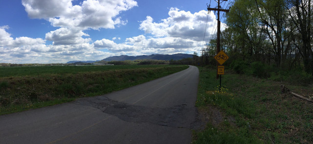
A rolling ride that circumnavigates Chilhowee Mountain. You'll ride through farmland and iconic hollars of East Tennessee
Détails de l'itinéraire
Autres itinéraires de Rollin' Appalachia
Happy Creek Loop
Exploring Southern Appalachia on two wheels
A fun route that leaves from the heart of Knoxville's Urban Wilderness. This loop has numerous sh... more
A fun route that leaves from the heart of Knoxville's Urban Wilderness. This loop has numerous short climbs and rollers, and takes you on Happy Creek Road...a tight and twisting road that could be described as singletrack, but for road bikes. (less)
A fun route that leaves from the heart of Knoxville's Urban Wilderness. This loop has numerous short climbs and rollers, and takes you on Happy Creek Road...a tight and twisting road that could be described ...more
A fun route that leaves from the heart of Knoxville's Urban Wilderness. This loop has numerous short climbs and rollers, and takes you on Happy Creek Road...a tight and twisting road that could be described as singletrack, but for road bikes. (less)
Chill by the Farr Multi-Surface Loop
Exploring Southern Appalachia on two wheels
A mixed surface ride that takes you from from the shores of Lake Chilhowee, over Mt Pleasant, and... more
A mixed surface ride that takes you from from the shores of Lake Chilhowee, over Mt Pleasant, and then up to the famed Farr Gap in Cherokee Nation Forest. A beautiful back-country ride on gravel and "marginal" asphalt. (less)
A mixed surface ride that takes you from from the shores of Lake Chilhowee, over Mt Pleasant, and then up to the famed Farr Gap in Cherokee Nation Forest. A beautiful back-country ride on gravel and "margina...more
A mixed surface ride that takes you from from the shores of Lake Chilhowee, over Mt Pleasant, and then up to the famed Farr Gap in Cherokee Nation Forest. A beautiful back-country ride on gravel and "marginal" asphalt. (less)
Waterville Epic
Exploring Southern Appalachia on two wheels
A truly epic route in the wilderness of the Appalachian Mountains. Big gravel climbs and descents along the Smoky Mountains and some fantastic overlooks make this a must do ride.
A truly epic route in the wilderness of the Appalachian Mountains. Big gravel climbs and descents along the Smoky Mountains and some fantastic overlooks make this a must do ride. (less)
Rock Creek Gravel Groval
Exploring Southern Appalachia on two wheels
A beautiful and challenging gravel loop along the northern edge of Big South Fork NRRA and throu... more
A beautiful and challenging gravel loop along the northern edge of Big South Fork NRRA and through Daniel Boone National Forest. You'll get a big helping of wilderness on this ride as you ride along ridge lines and in the Rock Creek gorge. (less)
A beautiful and challenging gravel loop along the northern edge of Big South Fork NRRA and through Daniel Boone National Forest. You'll get a big helping of wilderness on this ride as you ride along ridge l...more
A beautiful and challenging gravel loop along the northern edge of Big South Fork NRRA and through Daniel Boone National Forest. You'll get a big helping of wilderness on this ride as you ride along ridge lines and in the Rock Creek gorge. (less)
Wildcat Multi-Surface
Exploring Southern Appalachia on two wheels
A multi-surface route that has multiple, long, gravel road climbs in the back country of Cherokee... more
A multi-surface route that has multiple, long, gravel road climbs in the back country of Cherokee NF and a screemin' fast descent of Cherohala Skyway. This is a route for the mountain goats. (less)
A multi-surface route that has multiple, long, gravel road climbs in the back country of Cherokee NF and a screemin' fast descent of Cherohala Skyway. This is a route for the mountain goats.
A multi-surface route that has multiple, long, gravel road climbs in the back country of Cherokee NF and a screemin' fast descent of Cherohala Skyway. This is a route for the mountain goats. (less)
HARDford
Exploring Southern Appalachia on two wheels
A challenging multi-surface route in Cherokee National Forest with 3 notable climbs and fast descents. This is the loop that was used in the Hardford 50 gravel grinder race.
A challenging multi-surface route in Cherokee National Forest with 3 notable climbs and fast descents. This is the loop that was used in the Hardford 50 gravel grinder race. (less)


