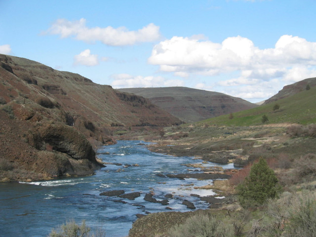
Sherar's Falls Scenic Bikeway |

|
ルートの概要
The Best of Oregon Riding
Traverse the strikingly scenic high desert canyon of north central Oregon on this 33-mile loop en route to the Bikeway’s namesake, Sherar's Falls, on the Deschutes River.
The below links provide detailed cues to ride the route in a clockwise direction.
See "Trip Planning Resources" in the Route Details below for cues to ride the route in a counter-clockwise direction.
ルートの詳細
Oregon Scenic Bikewaysによる他のルート
Madras Mtn Views Scenic Bikeway
The Best of Oregon Riding
The Madras Mountain Views Scenic Bikeway is a peaceful 30-mile loop through Central Oregon. Start... more
The Madras Mountain Views Scenic Bikeway is a peaceful 30-mile loop through Central Oregon. Starting and ending in Madras, it offers amazing views of Oregon’s volcanoes and agricultural and pastoral scenery showcases basalt palisades, many of the majestic Cascade Mountains, and Lake Billy Chinook. (less)
The Madras Mountain Views Scenic Bikeway is a peaceful 30-mile loop through Central Oregon. Starting and ending in Madras, it offers amazing views of Oregon’s volcanoes and agricultural and pastoral scenery ...more
The Madras Mountain Views Scenic Bikeway is a peaceful 30-mile loop through Central Oregon. Starting and ending in Madras, it offers amazing views of Oregon’s volcanoes and agricultural and pastoral scenery showcases basalt palisades, many of the majestic Cascade Mountains, and Lake Billy Chinook. (less)
Twin Bridges Scenic Bikeway
The Best of Oregon Riding
The Twin Bridges Loop is the most popular countryside riding loop from Bend. Beginning and ending... more
The Twin Bridges Loop is the most popular countryside riding loop from Bend. Beginning and ending in historic Drake Park in downtown Bend, the route is one of the premier scenic cycling routes in Oregon. (less)
The Twin Bridges Loop is the most popular countryside riding loop from Bend. Beginning and ending in historic Drake Park in downtown Bend, the route is one of the premier scenic cycling routes in Oregon.
The Twin Bridges Loop is the most popular countryside riding loop from Bend. Beginning and ending in historic Drake Park in downtown Bend, the route is one of the premier scenic cycling routes in Oregon. (less)
McKenzie Pass Scenic Bikeway
The Best of Oregon Riding
McKenzie Pass is without a doubt the most spectacular ride in Central Oregon, showcasing forests ... more
McKenzie Pass is without a doubt the most spectacular ride in Central Oregon, showcasing forests on both the east and west sides of the Cascades (they’re different) as well as a lava-rock moonscape at the top that’s unlike anything you’ll probably ever see on a bike ride again. (less)
McKenzie Pass is without a doubt the most spectacular ride in Central Oregon, showcasing forests on both the east and west sides of the Cascades (they’re different) as well as a lava-rock moonscape at the to...more
McKenzie Pass is without a doubt the most spectacular ride in Central Oregon, showcasing forests on both the east and west sides of the Cascades (they’re different) as well as a lava-rock moonscape at the top that’s unlike anything you’ll probably ever see on a bike ride again. (less)
Blue Mtn Century Scenic Bikeway
The Best of Oregon Riding
The 108-mile Blue Mountain Century Scenic Bikeway is a breathtakingly beautiful loop that starts ... more
The 108-mile Blue Mountain Century Scenic Bikeway is a breathtakingly beautiful loop that starts and ends in Heppner, a full-service community with secure places to leave your vehicle while you ride. The route travels through the Blue Mountains to Ukiah before looping back to Heppner, and is best ridden in two days. (less)
The 108-mile Blue Mountain Century Scenic Bikeway is a breathtakingly beautiful loop that starts and ends in Heppner, a full-service community with secure places to leave your vehicle while you ride. The rou...more
The 108-mile Blue Mountain Century Scenic Bikeway is a breathtakingly beautiful loop that starts and ends in Heppner, a full-service community with secure places to leave your vehicle while you ride. The route travels through the Blue Mountains to Ukiah before looping back to Heppner, and is best ridden in two days. (less)
Grande Tour Scenic Bikeway
The Best of Oregon Riding
Your wheels will sing under the big sky as miles of remote open road beckon and your cares melt a... more
Your wheels will sing under the big sky as miles of remote open road beckon and your cares melt away on the Grande Tour Scenic Bikeway. Starting at Riverside Park north of La Grande and passing through the communities of Island City, Union, North Powder, Baker City and Cove, this bikeway offers quiet country roads with stunning views of the Blue and Wallowa Mountains. The links to the left provide detailed cues to ride the route in a counter-clockwise direction. See "Trip Planning Resources" in the Route Details below for cues to ride the route in a clockwise direction. (less)
Your wheels will sing under the big sky as miles of remote open road beckon and your cares melt away on the Grande Tour Scenic Bikeway. Starting at Riverside Park north of La Grande and passing through the c...more
Your wheels will sing under the big sky as miles of remote open road beckon and your cares melt away on the Grande Tour Scenic Bikeway. Starting at Riverside Park north of La Grande and passing through the communities of Island City, Union, North Powder, Baker City and Cove, this bikeway offers quiet country roads with stunning views of the Blue and Wallowa Mountains. The links to the left provide detailed cues to ride the route in a counter-clockwise direction. See "Trip Planning Resources" in the Route Details below for cues to ride the route in a clockwise direction. (less)
Cascade-Siskiyou Scenic Bikeway
The Best of Oregon Riding
Oregon's Cascade-Siskiyou Scenic Bikeway is challenging by every definition, with more than 5,000... more
Oregon's Cascade-Siskiyou Scenic Bikeway is challenging by every definition, with more than 5,000 feet of climbing and steep winding descents--all on roads. The bikeway starts in Ashland, with most of the climbing in the first 15 miles. The region is so ecologically significant that 62,000 acres of it is designated as the Cascade-Siskiyou National Monument. The route ends with an thrilling 13-mile descent back to Ashland. (less)
Oregon's Cascade-Siskiyou Scenic Bikeway is challenging by every definition, with more than 5,000 feet of climbing and steep winding descents--all on roads. The bikeway starts in Ashland, with most of the cl...more
Oregon's Cascade-Siskiyou Scenic Bikeway is challenging by every definition, with more than 5,000 feet of climbing and steep winding descents--all on roads. The bikeway starts in Ashland, with most of the climbing in the first 15 miles. The region is so ecologically significant that 62,000 acres of it is designated as the Cascade-Siskiyou National Monument. The route ends with an thrilling 13-mile descent back to Ashland. (less)
Painted Hills Scenic Bikeway
The Best of Oregon Riding
Bicycling Oregon's Painted Hills Scenic Bikeway offers the opportunity to see millions of years o... more
Bicycling Oregon's Painted Hills Scenic Bikeway offers the opportunity to see millions of years of history revealed in the layers of mountains of earth, one color at a time. The hills get their name from the delicately colored stratifications in the soil of yellows, golds, blacks, and reds with Mars-like pillars formed by waterfalls and volcanic sludge. A closer look reveals ancient plant and wood fossils. The links to the left provide detailed cues to ride the full route. See "Trip Planning Resources" in the Route Details below for GPS files for each of the segments of the route shown on the map downloadable from the Oregon Parks and Recreation Department. (less)
Bicycling Oregon's Painted Hills Scenic Bikeway offers the opportunity to see millions of years of history revealed in the layers of mountains of earth, one color at a time. The hills get their name from the...more
Bicycling Oregon's Painted Hills Scenic Bikeway offers the opportunity to see millions of years of history revealed in the layers of mountains of earth, one color at a time. The hills get their name from the delicately colored stratifications in the soil of yellows, golds, blacks, and reds with Mars-like pillars formed by waterfalls and volcanic sludge. A closer look reveals ancient plant and wood fossils. The links to the left provide detailed cues to ride the full route. See "Trip Planning Resources" in the Route Details below for GPS files for each of the segments of the route shown on the map downloadable from the Oregon Parks and Recreation Department. (less)
Cascading Rivers Scenic Bikeway
The Best of Oregon Riding
Oregon's Cascading Rivers Scenic Bikeway passes through western Cascades forests along the Breite... more
Oregon's Cascading Rivers Scenic Bikeway passes through western Cascades forests along the Breitenbush and Clackamas Rivers between Detroit and Estacada. The links to the left provide detailed cues to ride the route starting in Detroit. See "Trip Planning Resources" in the Route Details below for cues to ride the route starting in Estacada. (less)
Oregon's Cascading Rivers Scenic Bikeway passes through western Cascades forests along the Breitenbush and Clackamas Rivers between Detroit and Estacada. The links to the left provide detailed cues to ride ...more
Oregon's Cascading Rivers Scenic Bikeway passes through western Cascades forests along the Breitenbush and Clackamas Rivers between Detroit and Estacada. The links to the left provide detailed cues to ride the route starting in Detroit. See "Trip Planning Resources" in the Route Details below for cues to ride the route starting in Estacada. (less)
Aufderheide Scenic Bikeway
The Best of Oregon Riding
The Aufderheide Scenic Bikeway starts in scenic Westfir and follows 60 miles of paved road as you... more
The Aufderheide Scenic Bikeway starts in scenic Westfir and follows 60 miles of paved road as you climb up almost 4,000 feet in elevation through an old-growth wonderland. You'll meander along the McKenzie River and encounter Douglas fir trees, rivers, and potentially wildlife such as elk and deer. Many recreational opportunities abound on the route, and it ends at the quaint town of Rainbow, nestled in the foothills of the Cascades. The link below provides detailed cues to ride the route starting in Westfir. See "Trip Planning Resources" in the Route Details below to ride the route starting in Rainbow. (less)
The Aufderheide Scenic Bikeway starts in scenic Westfir and follows 60 miles of paved road as you climb up almost 4,000 feet in elevation through an old-growth wonderland. You'll meander along the McKenzie R...more
The Aufderheide Scenic Bikeway starts in scenic Westfir and follows 60 miles of paved road as you climb up almost 4,000 feet in elevation through an old-growth wonderland. You'll meander along the McKenzie River and encounter Douglas fir trees, rivers, and potentially wildlife such as elk and deer. Many recreational opportunities abound on the route, and it ends at the quaint town of Rainbow, nestled in the foothills of the Cascades. The link below provides detailed cues to ride the route starting in Westfir. See "Trip Planning Resources" in the Route Details below to ride the route starting in Rainbow. (less)
Covered Bridges Scenic Bikeway
The Best of Oregon Riding
Oregon's Covered Bridges Scenic Bikeway starts and ends in Cottage Grove. The route follows the C... more
Oregon's Covered Bridges Scenic Bikeway starts and ends in Cottage Grove. The route follows the Cottage Grove Covered Bridge Tour Route, including the Row River Trail along Dorena Lake, before returning on lightly traveled country roads. (less)
Oregon's Covered Bridges Scenic Bikeway starts and ends in Cottage Grove. The route follows the Cottage Grove Covered Bridge Tour Route, including the Row River Trail along Dorena Lake, before returning on l...more
Oregon's Covered Bridges Scenic Bikeway starts and ends in Cottage Grove. The route follows the Cottage Grove Covered Bridge Tour Route, including the Row River Trail along Dorena Lake, before returning on lightly traveled country roads. (less)
Sisters to Smith Rock Scenic Bikeway
The Best of Oregon Riding
The Sisters to Smith Rock Scenic Bikeway provides riders with one of the most scenic and rewardin... more
The Sisters to Smith Rock Scenic Bikeway provides riders with one of the most scenic and rewarding rides in Central Oregon, taking cyclists past historical sites, the gentle curves of the Deschutes River, and spectacular views of the Cascade Mountains. (less)
The Sisters to Smith Rock Scenic Bikeway provides riders with one of the most scenic and rewarding rides in Central Oregon, taking cyclists past historical sites, the gentle curves of the Deschutes River, a...more
The Sisters to Smith Rock Scenic Bikeway provides riders with one of the most scenic and rewarding rides in Central Oregon, taking cyclists past historical sites, the gentle curves of the Deschutes River, and spectacular views of the Cascade Mountains. (less)
Tualatin Valley Scenic Bikeway
The Best of Oregon Riding
Oregon's Tualatin Valley Scenic Bikeway captures the best of the northern Willamette Valley inclu... more
Oregon's Tualatin Valley Scenic Bikeway captures the best of the northern Willamette Valley including friendly downtowns, fertile farmlands, lush natural areas and the Banks-Vernonia State Trail. (less)
Oregon's Tualatin Valley Scenic Bikeway captures the best of the northern Willamette Valley including friendly downtowns, fertile farmlands, lush natural areas and the Banks-Vernonia State Trail.
Oregon's Tualatin Valley Scenic Bikeway captures the best of the northern Willamette Valley including friendly downtowns, fertile farmlands, lush natural areas and the Banks-Vernonia State Trail. (less)
Willamette Valley Scenic Bikeway
The Best of Oregon Riding
Relive Oregon’s history, sample the agricultural bounty of the Willamette Valley, pedal through t... more
Relive Oregon’s history, sample the agricultural bounty of the Willamette Valley, pedal through tranquil scenery and make your own history by riding the first official Scenic Bikeway in the United States. The Bikeway follows its namesake river as it winds through the Willamette Valley, shaped by the Coast Range to the west and the towering Cascade Mountains to the east. The links to the left provide detailed cues to ride the route starting at Champoeg State Heritage Area. See "Trip Planning Resources" in the Route Details below to ride the route starting at Armitage County Park. (less)
Relive Oregon’s history, sample the agricultural bounty of the Willamette Valley, pedal through tranquil scenery and make your own history by riding the first official Scenic Bikeway in the United States. Th...more
Relive Oregon’s history, sample the agricultural bounty of the Willamette Valley, pedal through tranquil scenery and make your own history by riding the first official Scenic Bikeway in the United States. The Bikeway follows its namesake river as it winds through the Willamette Valley, shaped by the Coast Range to the west and the towering Cascade Mountains to the east. The links to the left provide detailed cues to ride the route starting at Champoeg State Heritage Area. See "Trip Planning Resources" in the Route Details below to ride the route starting at Armitage County Park. (less)
Old West Scenic Bikeway
The Best of Oregon Riding
Oregon's Old West Scenic Bikeway starts at Kam Wah Chung State Heritage Site in John Day and pass... more
Oregon's Old West Scenic Bikeway starts at Kam Wah Chung State Heritage Site in John Day and passes through the communities of Prairie City, Long Creek, Monument, Dayville and Mt Vernon before returning to John Day. This two- to three-day route offers a cornucopia of terrain and scenery, from rushing rivers to hot springs to fossil beds – and some attention-getting climbs. (less)
Oregon's Old West Scenic Bikeway starts at Kam Wah Chung State Heritage Site in John Day and passes through the communities of Prairie City, Long Creek, Monument, Dayville and Mt Vernon before returning to J...more
Oregon's Old West Scenic Bikeway starts at Kam Wah Chung State Heritage Site in John Day and passes through the communities of Prairie City, Long Creek, Monument, Dayville and Mt Vernon before returning to John Day. This two- to three-day route offers a cornucopia of terrain and scenery, from rushing rivers to hot springs to fossil beds – and some attention-getting climbs. (less)
Wild Rivers Coast Scenic Bikeway
The Best of Oregon Riding
Oregon's Wild Rivers Coast Scenic Bikeway offers visitors a wild and scenic river, lush cranberry... more
Oregon's Wild Rivers Coast Scenic Bikeway offers visitors a wild and scenic river, lush cranberry bogs, towering basalt seastacks and vast ocean views. The 60- mile ride is anchored in the quaint fishing hamlet of Port Orford, the oldest town on the Oregon coast. Here you can count on a great cup of coffee, and you’ll find a quiet, locally-owned hotel and an eclectic art gallery. (less)
Oregon's Wild Rivers Coast Scenic Bikeway offers visitors a wild and scenic river, lush cranberry bogs, towering basalt seastacks and vast ocean views. The 60- mile ride is anchored in the quaint fishing ham...more
Oregon's Wild Rivers Coast Scenic Bikeway offers visitors a wild and scenic river, lush cranberry bogs, towering basalt seastacks and vast ocean views. The 60- mile ride is anchored in the quaint fishing hamlet of Port Orford, the oldest town on the Oregon coast. Here you can count on a great cup of coffee, and you’ll find a quiet, locally-owned hotel and an eclectic art gallery. (less)
Oregon Outback Scenic Bikeway
The Best of Oregon Riding
Oregon Outback Scenic Bikeway is a wonderful cycling challenge filled with opportunities for wild... more
Oregon Outback Scenic Bikeway is a wonderful cycling challenge filled with opportunities for wildlife viewing and quiet solitude. The route is nestled in the beautiful Warner Mountains, located where the forested Cascades meet the high desert basin and range. High peaks, sheer cliffs, gorgeous lakes and ample solitude are yours to savor and share with pronghorn antelope, wetland birds, bighorn sheep and sage grouse. (less)
Oregon Outback Scenic Bikeway is a wonderful cycling challenge filled with opportunities for wildlife viewing and quiet solitude. The route is nestled in the beautiful Warner Mountains, located where the for...more
Oregon Outback Scenic Bikeway is a wonderful cycling challenge filled with opportunities for wildlife viewing and quiet solitude. The route is nestled in the beautiful Warner Mountains, located where the forested Cascades meet the high desert basin and range. High peaks, sheer cliffs, gorgeous lakes and ample solitude are yours to savor and share with pronghorn antelope, wetland birds, bighorn sheep and sage grouse. (less)
Crooked River Canyon Scenic Bikeway
The Best of Oregon Riding
The Crooked River Canyon Scenic Bikeway is a hidden gem in Central Oregon. This 37-mile out-and-b... more
The Crooked River Canyon Scenic Bikeway is a hidden gem in Central Oregon. This 37-mile out-and-back ride takes visitors from the community of Prineville, past the farm and ranch fields of the Crooked River Valley, then through the deeply incised and dramatic Crooked River Canyon. (less)
The Crooked River Canyon Scenic Bikeway is a hidden gem in Central Oregon. This 37-mile out-and-back ride takes visitors from the community of Prineville, past the farm and ranch fields of the Crooked River ...more
The Crooked River Canyon Scenic Bikeway is a hidden gem in Central Oregon. This 37-mile out-and-back ride takes visitors from the community of Prineville, past the farm and ranch fields of the Crooked River Valley, then through the deeply incised and dramatic Crooked River Canyon. (less)