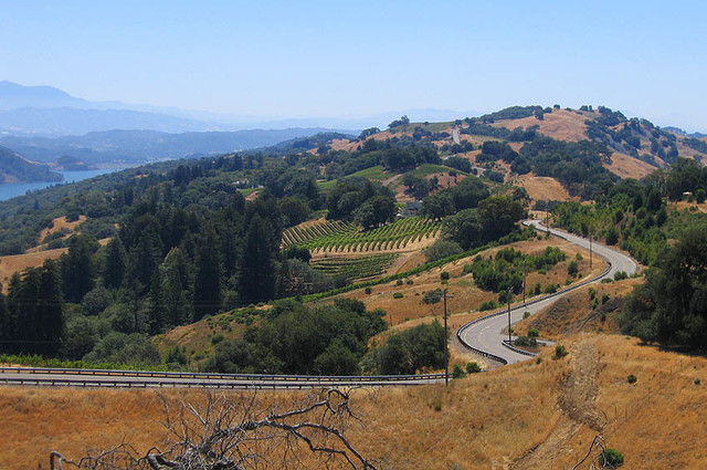
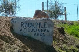
Rockpile-Advanced |

|
Route-overzicht
Sonoma, California Bike Tours & Rentals
Lake Sonoma is one of my favorite places in Sonoma County with vast rugged, endless wilderness. Rockpile Rd is the only public road that snakes along the ridge at the north end of Dry Creek Valley for 13 miles and comes to an end. On rare clear spring days, the top offers views of the snow peaked Snow Mountain at 7600 ft, in the Mendocino National wilderness over 100 miles away. Rockpile is a very challenging ride but a ride that's all about panoramic views, wilderness and low traffic.
Routedetails
Andere routes van Wine Country Bikes
Sonoma, California Bike Tours & Rentals
Explore the Alexander Valley wine region from the Northern Sonoma County town of Healdsburg. The... more
Explore the Alexander Valley wine region from the Northern Sonoma County town of Healdsburg. The route offers small rolling hills, broad vineyard vistas, boutique wineries and great lunch spots. Visit Silver Oak Winery and take a tour, have a gourmet lunch at Diavola Restaurant or take a swim at Francis Ford Coppola. Now that we offer E-bikes this route is appropriate for beginner to advanced riders with moderate traffic tolerance. Great ride for multiple day touring and returning guests. Rentals starting at $49.00. Upgrade to lightweight touring bike, Carbon Cervelo road bikes, or E-BIKES. Upload this route to your phone or device. (less)
Explore the Alexander Valley wine region from the Northern Sonoma County town of Healdsburg. The route offers small rolling hills, broad vineyard vistas, boutique wineries and great lunch spots. Visit Silv...more
Explore the Alexander Valley wine region from the Northern Sonoma County town of Healdsburg. The route offers small rolling hills, broad vineyard vistas, boutique wineries and great lunch spots. Visit Silver Oak Winery and take a tour, have a gourmet lunch at Diavola Restaurant or take a swim at Francis Ford Coppola. Now that we offer E-bikes this route is appropriate for beginner to advanced riders with moderate traffic tolerance. Great ride for multiple day touring and returning guests. Rentals starting at $49.00. Upgrade to lightweight touring bike, Carbon Cervelo road bikes, or E-BIKES. Upload this route to your phone or device. (less)
Sonoma, California Bike Tours & Rentals
Head north through the Dry Creek Valley and climb up through a few hills to the Lake Sonoma over... more
Head north through the Dry Creek Valley and climb up through a few hills to the Lake Sonoma overlook to get a 360 degree view of the area. On this ride you'll pass by the fish hatchery where thousands of salmon make their winter journey from the Pacific Ocean to the base of the dam. Roll through the valley, pick up a gourmet picnic lunch, get a little workout, take in some amazing vistas and visit a few wineries on the way home- how can you beat that? Recommend at least Lightweight hybrid ($59.00).This ride is now more accessible to all levels of riders as we now rent casual E-BIKES ($99.00). Great route for mixed level corporate team building! Upload this route to your phone or device. (less)
Head north through the Dry Creek Valley and climb up through a few hills to the Lake Sonoma overlook to get a 360 degree view of the area. On this ride you'll pass by the fish hatchery where thousands of sa...more
Head north through the Dry Creek Valley and climb up through a few hills to the Lake Sonoma overlook to get a 360 degree view of the area. On this ride you'll pass by the fish hatchery where thousands of salmon make their winter journey from the Pacific Ocean to the base of the dam. Roll through the valley, pick up a gourmet picnic lunch, get a little workout, take in some amazing vistas and visit a few wineries on the way home- how can you beat that? Recommend at least Lightweight hybrid ($59.00).This ride is now more accessible to all levels of riders as we now rent casual E-BIKES ($99.00). Great route for mixed level corporate team building! Upload this route to your phone or device. (less)
Sonoma, California Bike Tours & Rentals
Russian River Valley Loop is our #2 suggested Wine Country Bike route from the Town of Healdsburg... more
Russian River Valley Loop is our #2 suggested Wine Country Bike route from the Town of Healdsburg. Travel down the eastside and back up the westside of the Russian River Valley Wine Region, includes a few long-ish hills. Visit some of the boutique wineries along Westside Rd. We suggest bringing lunch with you as there aren't any places to pick up lunch along the route. We recommend our Lightweight hybrid ($49.00), aluminum road bike ($79.00), carbon Cervelo road bike ($99.00), or casual E-BIKES ($99.00). You can upload this route to your phone or device. (less)
Russian River Valley Loop is our #2 suggested Wine Country Bike route from the Town of Healdsburg. Travel down the eastside and back up the westside of the Russian River Valley Wine Region, includes a few l...more
Russian River Valley Loop is our #2 suggested Wine Country Bike route from the Town of Healdsburg. Travel down the eastside and back up the westside of the Russian River Valley Wine Region, includes a few long-ish hills. Visit some of the boutique wineries along Westside Rd. We suggest bringing lunch with you as there aren't any places to pick up lunch along the route. We recommend our Lightweight hybrid ($49.00), aluminum road bike ($79.00), carbon Cervelo road bike ($99.00), or casual E-BIKES ($99.00). You can upload this route to your phone or device. (less)
Sweetwater Springs to the Redwoods- Advanced
Sonoma, California Bike Tours & Rentals
From the heart of the Sonoma Wine Country, over the shoulder of Mt. Jackson and into the deep of ... more
From the heart of the Sonoma Wine Country, over the shoulder of Mt. Jackson and into the deep of the Armstrong Redwood Forest; this is classic Northern California riding. Don't let the shorter distance fool you- this little road is packed with challenge and adventure! (less)
From the heart of the Sonoma Wine Country, over the shoulder of Mt. Jackson and into the deep of the Armstrong Redwood Forest; this is classic Northern California riding. Don't let the shorter distance fool...more
From the heart of the Sonoma Wine Country, over the shoulder of Mt. Jackson and into the deep of the Armstrong Redwood Forest; this is classic Northern California riding. Don't let the shorter distance fool you- this little road is packed with challenge and adventure! (less)
Pine Flat-Dry Creek Valley-Advanced
Sonoma, California Bike Tours & Rentals
Pine Flat is one of the most popular climbs in Sonoma County specifically because it's one of the... more
Pine Flat is one of the most popular climbs in Sonoma County specifically because it's one of the more "gentle" climbs with 8 miles of 4-6% grades, great views, low traffic and is located in the National Auduban Canyon Ranch Preserve. The final few miles offer grades between 10-16%, so those looking for more of a challenge, ride the entire climb! The road comes to an end within 13 miles. We offer aluminum ($65.00) and carbon ($85.00) road bikes as well as performance E-bikes ($109.00) per day. (less)
Pine Flat is one of the most popular climbs in Sonoma County specifically because it's one of the more "gentle" climbs with 8 miles of 4-6% grades, great views, low traffic and is located in the National Aud...more
Pine Flat is one of the most popular climbs in Sonoma County specifically because it's one of the more "gentle" climbs with 8 miles of 4-6% grades, great views, low traffic and is located in the National Auduban Canyon Ranch Preserve. The final few miles offer grades between 10-16%, so those looking for more of a challenge, ride the entire climb! The road comes to an end within 13 miles. We offer aluminum ($65.00) and carbon ($85.00) road bikes as well as performance E-bikes ($109.00) per day. (less)
All Three Valleys-Intermediate/Advanced
Sonoma, California Bike Tours & Rentals
A local favorite! If you have one day to ride and want to ride 50 miles without a lot of climbing... more
A local favorite! If you have one day to ride and want to ride 50 miles without a lot of climbing, this is the ride. The loop takes you through three well known wine regions in northern Sonoma Valley. There's also a couple nice places to get lunch along the route. The terrain is flat to rolling on mostly newly paved roads mixed with some rougher sections- for a little local character. With our new PERFORMANCE E-BIKES mixed level riders can ride together!
You'll ride south-west-north through the Russian River Valley area and back through Dry Creek Valley, east-south over Canyon Rd and into Alexander Valley. (less)
A local favorite! If you have one day to ride and want to ride 50 miles without a lot of climbing, this is the ride. The loop takes you through three well known wine regions in northern Sonoma Valley. Ther...more
A local favorite! If you have one day to ride and want to ride 50 miles without a lot of climbing, this is the ride. The loop takes you through three well known wine regions in northern Sonoma Valley. There's also a couple nice places to get lunch along the route. The terrain is flat to rolling on mostly newly paved roads mixed with some rougher sections- for a little local character. With our new PERFORMANCE E-BIKES mixed level riders can ride together!
You'll ride south-west-north through the Russian River Valley area and back through Dry Creek Valley, east-south over Canyon Rd and into Alexander Valley. (less)
Sonoma, California Bike Tours & Rentals
The Cloverdale Summer Bridge is typically open from June through October (exact dates vary based ... more
The Cloverdale Summer Bridge is typically open from June through October (exact dates vary based on rainfall) and enables this popular flat to rolling ride that covers a good portion of Alexander and Dry Creek Valleys. A great summertime route that travels north through Alexander Valley before crossing over the Summer Bridge and hugging the western base of the Mayacama Mountain Range as you continue to the town of Cloverdale. Stop for a coffee, or just continue on over the small ridge into Dry Creek Valley and roll back down to Healdsburg. (less)
The Cloverdale Summer Bridge is typically open from June through October (exact dates vary based on rainfall) and enables this popular flat to rolling ride that covers a good portion of Alexander and Dry Cre...more
The Cloverdale Summer Bridge is typically open from June through October (exact dates vary based on rainfall) and enables this popular flat to rolling ride that covers a good portion of Alexander and Dry Creek Valleys. A great summertime route that travels north through Alexander Valley before crossing over the Summer Bridge and hugging the western base of the Mayacama Mountain Range as you continue to the town of Cloverdale. Stop for a coffee, or just continue on over the small ridge into Dry Creek Valley and roll back down to Healdsburg. (less)
Green Valley & The Boho-Advanced
Sonoma, California Bike Tours & Rentals
A great summer time route and very popular with local cyclists as it allows us to explore the bac... more
A great summer time route and very popular with local cyclists as it allows us to explore the back roads of Bohemian Sonoma County that are otherwise closed or flooded during the winter months. The bridge, making the road passable on Neely Rd, generally opens by the end of May. This route also offers a great deal more shade and in places, cooler temperatures. Mostly rolling with moderate hills but of course some short steeper sections, however, the gearing on our road bikes is suitable & for mixed level riders we offer Performance E-Bikes. (less)
A great summer time route and very popular with local cyclists as it allows us to explore the back roads of Bohemian Sonoma County that are otherwise closed or flooded during the winter months. The bridg...more
A great summer time route and very popular with local cyclists as it allows us to explore the back roads of Bohemian Sonoma County that are otherwise closed or flooded during the winter months. The bridge, making the road passable on Neely Rd, generally opens by the end of May. This route also offers a great deal more shade and in places, cooler temperatures. Mostly rolling with moderate hills but of course some short steeper sections, however, the gearing on our road bikes is suitable & for mixed level riders we offer Performance E-Bikes. (less)
Sonoma, California Bike Tours & Rentals
Head down the East side of the Russian River Valley to the old apple country of Western Sonoma C... more
Head down the East side of the Russian River Valley to the old apple country of Western Sonoma County-foothills of the Coastal Range. You'll travel through micro-climates and changing terrain as you ride towards the Pacific Ocean. Even though you're not far from the ocean a significant low/steep mountain range divides this region from the majestic Pacific coast line.We now rent E-BIKES making this ride accessible for all levels to enjoy. Stop for a great lunch in the little town of Graton and maybe a visit to Iron Horse Vineyards or Ektimo Winery, before a beautiful return trip brings you back up the West Side of the valley, past some of the best known boutique wineries in the Russian River Wine Region. This route is part of our popular 5 DAY SONOMA ADVENTURE TOUR which is one of our "Town to Town" cycling tours. (less)
Head down the East side of the Russian River Valley to the old apple country of Western Sonoma County-foothills of the Coastal Range. You'll travel through micro-climates and changing terrain as you ride t...more
Head down the East side of the Russian River Valley to the old apple country of Western Sonoma County-foothills of the Coastal Range. You'll travel through micro-climates and changing terrain as you ride towards the Pacific Ocean. Even though you're not far from the ocean a significant low/steep mountain range divides this region from the majestic Pacific coast line.We now rent E-BIKES making this ride accessible for all levels to enjoy. Stop for a great lunch in the little town of Graton and maybe a visit to Iron Horse Vineyards or Ektimo Winery, before a beautiful return trip brings you back up the West Side of the valley, past some of the best known boutique wineries in the Russian River Wine Region. This route is part of our popular 5 DAY SONOMA ADVENTURE TOUR which is one of our "Town to Town" cycling tours. (less)
Sonoma, California Bike Tours & Rentals
The perfect Wine Country Bike Ride- quiet roads, beautiful views, great wineries and a wonderful ... more
The perfect Wine Country Bike Ride- quiet roads, beautiful views, great wineries and a wonderful lunch stop. The Dry Creek Valley is home to many small production, family owned, award winning wineries so it's difficult to decide on just a few-solution- visit the area often. This ride starts in the "Culinary Town" of Headlsburg, in northern Sonoma County, California. This is always the first ride we recommend and the further up valley you travel the quieter and prettier it gets. We now offer pedal assist E-BIKES so you can cover more ground during your day BUT still get a work out because that's what's really important. GROUPS PLEASE SEE INFO BELOW "PLANNING YOUR RIDE" and or give us a call for bike preference and winery info. Upload this easy to follow route to your phone or device so you can access turn by turn voice navigation. (less)
The perfect Wine Country Bike Ride- quiet roads, beautiful views, great wineries and a wonderful lunch stop. The Dry Creek Valley is home to many small production, family owned, award winning wineries so it...more
The perfect Wine Country Bike Ride- quiet roads, beautiful views, great wineries and a wonderful lunch stop. The Dry Creek Valley is home to many small production, family owned, award winning wineries so it's difficult to decide on just a few-solution- visit the area often. This ride starts in the "Culinary Town" of Headlsburg, in northern Sonoma County, California. This is always the first ride we recommend and the further up valley you travel the quieter and prettier it gets. We now offer pedal assist E-BIKES so you can cover more ground during your day BUT still get a work out because that's what's really important. GROUPS PLEASE SEE INFO BELOW "PLANNING YOUR RIDE" and or give us a call for bike preference and winery info. Upload this easy to follow route to your phone or device so you can access turn by turn voice navigation. (less)
Geysers Road Loop- Advanced
Sonoma, California Bike Tours & Rentals
This challenging and remote ride heads north from Healdsburg along the vineyards of the Alexande... more
This challenging and remote ride heads north from Healdsburg along the vineyards of the Alexander Valley to the town of Cloverdale. Here you'll head east and follow Big Sulfur Creek, climbing for almost 14 miles to the first summit, into the heart of the Mayacamas Mountains. You'll eventually finish with a spectacular dive back into the Wine Country. Not for the unfit or faint of heart- adventure guaranteed. Great for visiting advanced level bike groups. WE RECOMMEND LEAVING EARLY AS TEMPERATURE AND EXPOSURE ARE FACTORS ON THIS ROUTE. Take a look at the map for info on SUMMITS, GRADES and areas to use EXTREME CAUTION. We rent Carbon Road bikes- appropriate gearing- $99.00/day. (less)
This challenging and remote ride heads north from Healdsburg along the vineyards of the Alexander Valley to the town of Cloverdale. Here you'll head east and follow Big Sulfur Creek, climbing for almost 14 ...more
This challenging and remote ride heads north from Healdsburg along the vineyards of the Alexander Valley to the town of Cloverdale. Here you'll head east and follow Big Sulfur Creek, climbing for almost 14 miles to the first summit, into the heart of the Mayacamas Mountains. You'll eventually finish with a spectacular dive back into the Wine Country. Not for the unfit or faint of heart- adventure guaranteed. Great for visiting advanced level bike groups. WE RECOMMEND LEAVING EARLY AS TEMPERATURE AND EXPOSURE ARE FACTORS ON THIS ROUTE. Take a look at the map for info on SUMMITS, GRADES and areas to use EXTREME CAUTION. We rent Carbon Road bikes- appropriate gearing- $99.00/day. (less)
Sonoma, California Bike Tours & Rentals
This is a favorite route for bike clubs and cyclists throughout the area- and with good reason. T... more
This is a favorite route for bike clubs and cyclists throughout the area- and with good reason. The quiet intimate scenes of small family run vineyards in Dry Creek Valley, combined with the beautiful broad vistas of the Alexander Valley, paint an unforgettable picture of the northern Sonoma County Wine Country. We now offer E-Bikes so no one is left behind in a group or make the most of your day and cover some extra rolling miles. Have lunch in Geyserville and if you'd like to visit a winery check out Locals tasting room or Silver Oak Winery. (less)
This is a favorite route for bike clubs and cyclists throughout the area- and with good reason. The quiet intimate scenes of small family run vineyards in Dry Creek Valley, combined with the beautiful broad ...more
This is a favorite route for bike clubs and cyclists throughout the area- and with good reason. The quiet intimate scenes of small family run vineyards in Dry Creek Valley, combined with the beautiful broad vistas of the Alexander Valley, paint an unforgettable picture of the northern Sonoma County Wine Country. We now offer E-Bikes so no one is left behind in a group or make the most of your day and cover some extra rolling miles. Have lunch in Geyserville and if you'd like to visit a winery check out Locals tasting room or Silver Oak Winery. (less)
Sonoma Coast-69 miles Advanced
Sonoma, California Bike Tours & Rentals
This might be the ultimate Sonoma County Adventure. From the Wine Country Town of Healdsburg you’... more
This might be the ultimate Sonoma County Adventure. From the Wine Country Town of Healdsburg you’ll roll through the vineyards of the inland valleys, climb the steep Coastal Range and descend to the crashing Pacific. After riding one of the most beautiful sections of the California Coast, you’ll follow the
Russian River back inland as it winds its way through the Redwoods and back to Wine Country. Ride a lot but want a little extra help? We now offer Performance E-BIKES but you'll still get a workout! Want to do this ride but maybe not all in one day? Check out our 5 DAY/4 NIGHT SONOMA ADVENTURE TOUR, it offers so much more.... (less)
This might be the ultimate Sonoma County Adventure. From the Wine Country Town of Healdsburg you’ll roll through the vineyards of the inland valleys, climb the steep Coastal Range and descend to the crashing...more
This might be the ultimate Sonoma County Adventure. From the Wine Country Town of Healdsburg you’ll roll through the vineyards of the inland valleys, climb the steep Coastal Range and descend to the crashing Pacific. After riding one of the most beautiful sections of the California Coast, you’ll follow the
Russian River back inland as it winds its way through the Redwoods and back to Wine Country. Ride a lot but want a little extra help? We now offer Performance E-BIKES but you'll still get a workout! Want to do this ride but maybe not all in one day? Check out our 5 DAY/4 NIGHT SONOMA ADVENTURE TOUR, it offers so much more.... (less)
Skaggs- Advanced
Sonoma, California Bike Tours & Rentals
Wow! This route is truly epic and for fit/experienced riders only. Part of the Terrible Two Breve... more
Wow! This route is truly epic and for fit/experienced riders only. Part of the Terrible Two Brevet course. A favorite for hard core seasoned cyclists. About 9000 ft worth of climbs on remote roads through the coastal range to the Pacific Ocean and back -so please plan carefully. North from Healdsburg, west through the mountains, south along the coast before heading on mercifully easier terrain, through the Russian River Valley and back to Healdburg. You can consider doing this route in two or three days as you can find some great lodging at the coast. Great idea for bike clubs and groups. Let us plan it for your group! (less)
Wow! This route is truly epic and for fit/experienced riders only. Part of the Terrible Two Brevet course. A favorite for hard core seasoned cyclists. About 9000 ft worth of climbs on remote roads through ...more
Wow! This route is truly epic and for fit/experienced riders only. Part of the Terrible Two Brevet course. A favorite for hard core seasoned cyclists. About 9000 ft worth of climbs on remote roads through the coastal range to the Pacific Ocean and back -so please plan carefully. North from Healdsburg, west through the mountains, south along the coast before heading on mercifully easier terrain, through the Russian River Valley and back to Healdburg. You can consider doing this route in two or three days as you can find some great lodging at the coast. Great idea for bike clubs and groups. Let us plan it for your group! (less)
Chalk Hill Loop-Intermediate/Advanced
Sonoma, California Bike Tours & Rentals
This is considered an Intermediate to Advanced route and has a bit of elevation gain, a few good... more
This is considered an Intermediate to Advanced route and has a bit of elevation gain, a few good hills on Chalk Hill Rd but in general, the terrain is flat to rolling. As well, this route does travel through some higher traffic areas in the town of Windsor in order to get over to Chalk Hill Rd so it's suited for riders that have good traffic tolerance. This is a popular route for those staying in the town of Windsor or riding multiple days in the area and wish to stay in the valleys. Many local club rides begin at a park near Chalk Hill. (less)
This is considered an Intermediate to Advanced route and has a bit of elevation gain, a few good hills on Chalk Hill Rd but in general, the terrain is flat to rolling. As well, this route does travel throug...more
This is considered an Intermediate to Advanced route and has a bit of elevation gain, a few good hills on Chalk Hill Rd but in general, the terrain is flat to rolling. As well, this route does travel through some higher traffic areas in the town of Windsor in order to get over to Chalk Hill Rd so it's suited for riders that have good traffic tolerance. This is a popular route for those staying in the town of Windsor or riding multiple days in the area and wish to stay in the valleys. Many local club rides begin at a park near Chalk Hill. (less)
Bottle Rock-Experienced Advanced
Sonoma, California Bike Tours & Rentals
Bottle Rock ride is designed for seasoned riders who are not new to hilly century rides. Lake Co... more
Bottle Rock ride is designed for seasoned riders who are not new to hilly century rides. Lake County is known to be hilly and windy with twisty technical descents and varying road conditions-this ride includes a steep gravel 2 mile long downhill section. That said, if you consider yourself an experienced/advanced rider this is a truly spectacular ride! Best time of year is early spring as it's hot in the summer and during the spring you'll have wild flowers and great views of Mt. Snow and the Sierras snow topped mountains. (less)
Bottle Rock ride is designed for seasoned riders who are not new to hilly century rides. Lake County is known to be hilly and windy with twisty technical descents and varying road conditions-this ride inclu...more
Bottle Rock ride is designed for seasoned riders who are not new to hilly century rides. Lake County is known to be hilly and windy with twisty technical descents and varying road conditions-this ride includes a steep gravel 2 mile long downhill section. That said, if you consider yourself an experienced/advanced rider this is a truly spectacular ride! Best time of year is early spring as it's hot in the summer and during the spring you'll have wild flowers and great views of Mt. Snow and the Sierras snow topped mountains. (less)